Maria de la Salut
| Maria de la Salut parish | ||
|---|---|---|
| coat of arms | Map of Spain | |

|
|
|
| Basic data | ||
| Autonomous Community : | Balearic Islands | |
| Island: | Mallorca | |
| Comarca : | Plà de Mallorca | |
| Coordinates | 39 ° 40 ′ N , 3 ° 4 ′ E | |
| Height : | 123 msnm | |
| Area : | 30.49 km² | |
| Residents : | 2,227 (Jan 1, 2019) | |
| Population density : | 73.04 inhabitants / km² | |
| Postal code : | 07519 | |
| Municipality number ( INE ): | 07035 | |
| Nearest airport : | Palma ( Son Sant Joan / Palma de Mallorca , 32 km ) | |
| administration | ||
| Official language : | Catalan , Castilian | |
| Mayor : | Antoni Mulet Campins ( PP ) | |
| Address of the municipal administration: | Plaça des Pou, 13 07519 Maria de la Salut |
|
| Website : | www.ajmariadelasalut.net | |
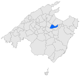
| Location of the municipality | ||
Mallorca
|
||
Maria de la Salut is one of the 53 communities on the Spanish Balearic island of Mallorca . The place has had the addition "de la Salut" only since 1916.
On January 1, 2019, Maria de la Salut had 2227 inhabitants, 2031 of them in the town of the same name (as of 2008). The proportion of foreigners in the municipality was 16.09% (337 people), the proportion of German residents 2.0% (42 people). 4 Swiss people also lived in the community. The locals call themselves Mariando for men and Marianda for women.
Attractions
- Parish church Mare de Déu de la Salut from the 17th century
- Son Roig mansion
- Son Puig windmill from the 17th century
- es Velar archaeological site ( Talayot culture )
Festivals
- Festa de la Mare de Déu de la Salut, patronage festival , September 8th
Individual evidence
- ↑ Cifras oficiales de población resultantes de la revisión del Padrón municipal a 1 de enero . Population statistics from the Instituto Nacional de Estadística (population update).
