Cala Sequer
| Cala Sequer beach | ||
|---|---|---|
| location | Manacor municipality | |
| Geographical location | 39 ° 29 '39 " N , 3 ° 17' 31" E | |
|
|
||
| length | 25 m | |
| width | 40 m | |
| nature | Sand and rubble | |
| water | clean | |
| Surroundings | natural | |
| tourism | ||
| Visitor frequency | little visited | |
| Parking spaces | no | |
| monitoring | no | |
| Nudism | Yes | |
| next hospital | Hospital de Manacor (15.2 km) | |
| next port | Porto Cristo (6 km) | |
| Beaches and bays in Mallorca | ||
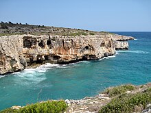
Cala Sequer is a small bay with a sandy beach on the east coast of the Spanish Balearic island of Mallorca . It is located in the southeast of the municipality of Manacor between the towns of Cales de Mallorca and S'Estany d'en Mas .
Location and description
The Cala Sequer is located away from the nearest tourist settlements Cales de Mallorca, 3.5 kilometers to the south, and S'Estany d'en Mas, 2.5 kilometers northeast, in the nature reserve Cales Verges de Manacor (type ANEI - Àrea natural d ' especial interès). It is an elongated sea inlet extending west into the interior of the island between the smaller bays of the adjoining Cala Enganapastor in the northeast and the 400 meters south of Caló des Serral .
The beach of Cala Sequer, made of sand mixed with rubble , is around 25 meters long and flanked by rocks that form a cliff coast towards the bay exit . On the north side of the beach is a partly decayed ends dry stone wall (margin) that line the Regueró de Cala Sequer moves inland, a torrent ( Torrent ), referred to herein as Regueró called ( "trickle") only during heavy rainfall water leads. Behind the 40 meter wide beach, the terrain slowly rises along the torrent to the Son Josep de Baix estate . The surrounding vegetation is partly made up of shrubs and low trees as well as pine forests . One kilometer northwest of the bay is the Cova de sa Gleda - Camp des Pou , the longest underwater cave in Europe.
Access
The original access to the bay from the Son Josep de Baix estate is blocked by the closed enclosure of the property located south directly above Cala Sequer . From the entrance gate of the enclosed property, a narrow path leads along the fence first northwards, then eastwards down to the bay. Furthermore, Cala Sequer can be reached from the sea or along the rocky coastline. The latter is possible from the southern Caló des Serral , from where a path leads up to Son Josep de Baix , as well as from Cala Varques 700 meters to the northeast, but this is difficult due to the lack of a path. Two kilometers west of Cala Sequer , the MA-4014 road runs between Porto Cristo and Portocolom .
literature
- Bartomeu Amengual Gomila: Mallorca's coasts from the air . Detailed and practical travel guide with aerial photos of Mallorca's coasts. 6th edition. Editorial GeoPlaneta, Barcelona 2000, ISBN 84-08-01821-3 , Cala Varques - Cala Seguer, p. 66 (Spanish, original title: Aeroguía del litoral de Mallorca . Translated by Gabriele Grauwinkel and Susanne Pospiech).
- Miguel Ángel Álvarez Alperi: Comprehensive Beach Guide Mallorca + Cabrera . 1st edition. Ediciones El Cohete, Gijón 2001, ISBN 84-87933-08-4 , Platja Cala Sequer, p. 111 .
- Belén Menéndez Solar: Guide de Playas de Mallorca . 1st edition. Ediciones El Cohete, Gijón 2008, ISBN 978-84-87933-11-0 , Cala Sequer, p. 85 (Spanish).
supporting documents
- Manacor Turístic: Environmental Atlas Manacor , Ajuntament de Manacor / Delegació de Turisme / Delegació de Medi Ambient 2008
- Manacor Turístic: Mapa topogràfic del terme municipal de Manacor , topographic map 1: 40,000, Ajuntament de Manacor / Delegació de Turisme 2007


