
Portopetro
| Santanyí municipality: Portopetro | |||
|---|---|---|---|

|
|||
| coat of arms | Map of Spain | ||
 Help on coat of arms |
|
||
| Basic data | |||
| Autonomous Community : | Balearic Islands | ||
| Island: | Mallorca | ||
| Comarca : | Migjorn | ||
| Coordinates | 39 ° 22 ' N , 3 ° 13' E | ||
| Residents : | 500 (2011) INE | ||
| Postal code : | 07691 | ||
| Area code: | 07057000200 | ||

Portopetro (or Porto Petro ) is a port on the Spanish Balearic island of Mallorca . It is located on the southeast coast in the Migjorn region .
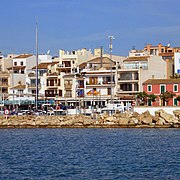
Portopetro belongs to the municipality of Santanyí and is located about 1.5 kilometers south of the center of the larger, but also younger town of Cala d'Or . Portopetro, first mentioned in the 13th century, has around 500 inhabitants today. The center of the town is the Plaza Calo de Moix. There are three medium-sized hotel complexes.
port
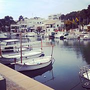
The port is located on the western side of the large Sa Platja bay and extends into the small Calo de Moix bay . The restaurants and bars of the village are grouped up to the end of the historic harbor, which is still mainly used as a fishing port today, but also has a small yacht harbor (marina) for tourism.
There is a ferry connection to the island of Cabrera .
Attractions
On the headland Punta de sa Torre are the Torre Portopetro (tower) and the Far de Portopetro (beacon)
Views
Buildings in the port
The harbor

Small boathouses

Torre de Portopetro

Far de Portopetro
.jpg)

.jpg)


beaches

Caló des Homme Morts

Caló des sa Torre

Cala Barca Trencada

Caló des Borgit


- Caló des Homme Morts (bay with sandy beach)
- Caló des sa Torre (bay with sandy beach)
- Cala Barca Trencada (bay with sandy beach), approx. 1 km
- Caló des Borgit (bay with sandy beach), approx. 1.5 km
- Ses Fonts de n'Alís (bay with sandy beach) and S'Amarador (bay with sandy beach) in Cala Mondragó , approx. 2-3 km
Parc natural de Mondragó
Not far from Cala d'Or and Portopetro is the nature reserve Parc natural de Mondragó with the beaches Ses Fonts de n'Alís and S'Amarador in the double bay of Cala Mondragó. The park with free entry is recommended for short hikes or a swim on the beach.