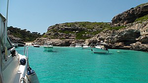
Caló des Màrmols
| Caló des Màrmols beach | ||
|---|---|---|
| location | Santanyí municipality | |
| Geographical location | 39 ° 17 '21 " N , 3 ° 5' 26" E | |
|
|
||
| length | 40 m | |
| width | 18 m | |
| nature | Sand and rocks | |
| water | clean, moderate swell | |
| Surroundings | natural | |
| tourism | ||
| Visitor frequency | low | |
| Parking spaces | no | |
| monitoring | no | |
| Nudism | Yes | |
| next hospital | Hospital de Manacor (33.6 km) | |
| next port | Cala Figuera (8.3 km) | |
| Beaches and bays in Mallorca | ||
Caló des Màrmols ('little marble bay'), in Castilian Cala Mármols , is a bay in the southeast of the Spanish Balearic island of Mallorca . It is located on the coast of the municipality of Santanyí, southwest of the town of Cala Llombards in the direction of Cap de ses Salines , the southern cape of Mallorca.
Location and description
The Caló des Màrmols is located 3.7 kilometers southwest of the settlement of S'Almunia or S'Almonia , part of the town of Cala Llombards. The capital of the municipality Santanyí is 7.4 kilometers northeast of the bay, the next larger town Es Llombards 5.6 kilometers north. The hinterland of the Caló des Màrmols forms the property ( Catalan possesió ) Rafal des Porcs . The bay is bounded in the southwest by the Punta des Màrmols and in the northeast by the area of sa Dent . It stretches about 200 meters to the northwest into the interior of the island.
On the northwest side of Caló des Màrmols there is a sandy beach about 40 meters long and 18 meters wide . It is framed by the steep coast and is interspersed with larger rocks. The size of the sand area varies and is flooded when the waves are strong. Seagrass deposits can occur on the shore . On the steep bank and behind the beach, a few pines and shrubbery grow into the rock cut that was washed out by the Torrent des Màrmols, which flows into the bay and rarely carries water.
Access
Follow the MA-6110 road, which starts between Es Llombards and Ses Salines , to the Cap de ses Salines at the southernmost point of Mallorca. Behind the area of the lighthouse begins an approximately 5.5 kilometers long coastal footpath to the northeast. Hiking guides show a running time of around 1½ hours.
literature
- Bartomeu Amengual Gomila: Mallorca's coasts from the air . Detailed and practical travel guide with aerial photos of Mallorca's coasts. 6th edition. Editorial GeoPlaneta, Barcelona 2000, ISBN 84-08-01821-3 , Caló des Màrmols, p. 44 (Spanish: Aeroguía del litoral de Mallorca . Translated by Gabriele Grauwinkel and Susanne Pospiech).
- Miguel Ángel Álvarez Alperi: All the beaches of Mallorca . 1st edition. Laluzenpapel, Gijón 2012, ISBN 978-84-938783-1-3 , Caló des Màrmols beach, p. 226 (Spanish: Todas las playas de Mallorca . Translated by Meike Schirmeister).
- Belén Menéndez Solar: Guide de Playas de Mallorca . 1st edition. Ediciones El Cohete, Gijón 2008, ISBN 978-84-87933-11-0 , Cala Mármols, p. 40 (Spanish).
Individual evidence
- ↑ Senderisme a Mallorca. Consell de Mallorca, accessed June 11, 2020 (interactive map).
- ↑ Calo des Marmols. www.mallorca-beaches.com, accessed June 11, 2020 .
- ^ Bernhard Irlinger, Wolfgang Heitzmann: Mallorca. The 40 most beautiful tours . Bruckmann's hiking guide. Bruckmann, Munich 2011, ISBN 978-3-7654-5175-1 , Am Cap de ses Salines, p. 160 .
Web links
- Location of the beach
- Beach description (German)

