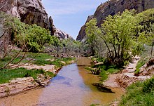
Calf Creek Canyon
| Calf Creek Canyon | ||
|---|---|---|
| Lower Calf Creek Falls | ||
|
|
||
| Location: | Utah , United States | |
| Next city: | Escalante (Utah) | |
The Calf Creek Canyon is located in southern Utah in the southwest of the USA , between the places Escalante and Boulder City and is part of the Grand Staircase-Escalante National Monument . The Calf Creek flowing through the canyon from north to south got its name from the early settlers (English pioneers) who used the canyon as a natural pen to wean the calves.
The canyon can be reached via Utah State Route 12 south of Boulder City. The entrance is at a location labeled Calf Creek Recreation Area . From here a 5 km long trail leads to the base of Lower Calf Creek Falls , a spectacular 40 meter high waterfall.
The waterfall
Lower Calf Creek Falls was one of the hidden and under-visited attractions in southern Utah for many years, but the creation of the National Monument gradually made it better known. The Calf Creek, the source of which is about 12 km above the falls, initially flows through the upper Calf Creek Canyon and flows through a V-shaped channel just before the waterfall until it cascades over almost vertical cliffs 40 meters into the depth. The water is caught by a large pond, which is bordered on three sides by high walls made of Navajo sandstone. The towering rocks are close to the water by large stains bright blue and green algae covered and wearing dark vertical strip of desert varnish (engl. Desert varnish). The whole scene is one of the nicest things to see in the attraction-rich southern Utah.
Although the falls are only 300 meters from the highway, they can only be viewed from there by a daring climb down into the upper canyon. Normal access is a 3-mile (3-mile) trail that begins at the Calf Creek Recreation Area parking lot. At this point, the lower canyon walls allow the road to descend to the level of Calf Creek for the first time and remain there until the creek joins the Escalante River about 2 km further south .
The canyon
The trail to the waterfall comprises a total of only a slight slope, but places some steep and sandy sections and is subjected to a strong sunlight. The walk to the falls and back takes about 3–4 hours and runs on the west side of the stream, generally a few meters above the canyon floor, which is consistently covered by reeds and thick grass. You pass three places with Indian rock paintings ( petroglyphs ), and the ruins of two former stone granaries in the rock walls on the opposite side of the canyon. After about 3 km, the path runs closer to the stream and becomes more shady, as the canyon walls become steeper and the path leads through a section of canyon made of trees and bushes. Here you can see particularly beautiful dark strips of desert varnish on the rocks - created by ferrous minerals and evaporating rainwater.
You can hear the falls from a distance, but they are hidden from view until just before the end of the trail. They face south-east and are in the shade most of the day - the best time to take pictures is between 9 and 10 a.m.
Animals in the canyon
Despite the desert climate, there is abundant animal life in the canyon. You can spot crows, woodpeckers, eagles, hummingbirds, blue thrushes, mourning pigeons and wild turkeys. There are also deer, porcupines, beavers, lizards and snakes here.
The highway was built in 1938. Until then, supplies and mail had to be carried to Boulder on the back of mules and packhorses via Hell's Backbone Road or the Boulder Mail Trail, both arduous and not harmless routes. It is said that Boulder was the last city in the United States to be supplied with mules.


