Caludon Castle
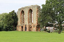
Caludon Castle is a ruined castle in Coventry in the West Midlands administrative division of England . Only a fragment of a sandstone wall remains of the castle , which is listed by English Heritage as a historical building of the first degree and is under protection as a Scheduled Monument . Another property with a moat is located 190 meters south of the castle ruins and is considered a dedicated Scheduled Monument. The ruins are now in a city park administered by the Coventry City Council, but much of the castle grounds were sold and residential buildings developed in the early 20th century.
The area had been built on since the 11th century at the latest. The first building, which before the Norman conquest of England was, was a large house that after the conquest by the Normans of title Earl of Chester was. In the 13th century, the Segrave family received the house, which was first described as a mansion in 1239 . In 1305 the family got the right to fortify the house (English: License to crenellate), and at that time the house was probably converted into a castle. In 1354 the family received another such permit and the castle was rebuilt again. In the 14th century it came into the possession of Thomas Mowbray, 1st Duke of Norfolk , who was exiled in 1398, after which the castle fell into disrepair. Mowbray's son John inherited the building. It remained in the Mowbray family until 1481 when it fell to William de Berkeley, 1st Marquess of Berkeley . It was rebuilt again in 1580, this time into a stately home after it had been in ruins since Thomas Mowbray's exile. However, the house was destroyed again in 1662 and was not rebuilt until 1800. Then the ruins were used to build a farmhouse on the site.
The property was divided and most of it was sold in 1815. It remained in the hands of various private owners until the Coventry Corporation bought the land after the First World War and built houses on it.
architecture
The remains of Caludon Castle are now in Wyken , a neighborhood east of Coventry city center. However, the property was significantly larger than it is today until parts of it were sold in the 19th century. Historically, the site was a separate part of St Michaal's parish , but was added to the Wyken parish in 1894 , which in turn became part of Coventry in 1928. The border of the property originally ran from the Sowe Bridge (today: Clifford Bridge ) over the Sowe in the southeast to the hill at Stoke Heath in the northwest.
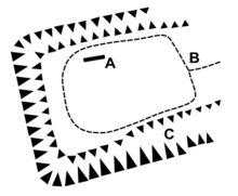
The original castle had an oval plan and was surrounded by a defensive wall with towers and a moat. The entrance led through a gatehouse with a bridge on the east side. Most of the living quarters were to the north and west of the enclosure, while the kitchens and business premises were to the east and south. Various farm buildings related to the castle are just outside the moat, along with a bowling green , gardens and a four-acre field called "The Pool". The property was converted into a stately home around 1580, with many outbuildings remaining, e.g. B. the "Porter's Lodge" and the brewery.
During a survey in 2008, the foundations of a rectangular building that was oriented to the north-northwest were found. It is said to be the remains of a large knight's hall , 33 meters long and 13 meters wide. Magnetic anomalies were found north of the knight's hall, which can be attributed to a complex of residential buildings that served as a mansion. The same survey revealed large magnetic deviations in the eastern part of the property, which could indicate buried rubble from the demolition of a farmhouse or the remains of filled cellars that are suspected to be on the site. Evidence was also found of the existence of a walkway around the property's internal buildings. According to the evidence found, it is assumed that the magnetic deviations indicate more than one construction phase, even if this could not be proven beyond doubt with the methods used.
A moat about 190 meters south of the castle was dug in the Middle Ages, probably around the time the castle was rebuilt in 1305. This remnant is a separate Scheduled Monument and encloses about 0.4 hectares of land. The moat could have been an enclosure of a farm that was connected to the castle.
history
The site was originally built on with a house that was built before the Norman conquest of England. After the conquest, it came into the possession of the Earl of Chester. Around 1232 Ranulf de Blondeville, 4th Earl of Chester , gave the house to Stephen of Seagrave , the then Justiciar of England. His son Gilbert of Seagrave inherited the property and bequeathed it to his son Nicholas Seagrave , who was appointed Baron Segrave . The house was first described as a mansion in 1239 and was then the only permanent residence of a nobleman in Coventry. The Caludon estate extended to Wyken in the north in 1279 when Nicholas de Seagrave bought a carucata and mill.
The house was thought to have been converted into a castle in 1305 when John Seagrave, 2nd Baron Seagrave , Nicholas' son, received the right from King Edward I to fortify his house, that is, to provide it with a parapet with rectangular cutouts through which Archers could shoot - at that time more of a status symbol, as well as providing it with a ditch and a wall. The property was also expanded to include a chapel and various outbuildings. Another renovation was carried out in 1354 when another license to fortify the property was obtained. In the second half of the 14th century Thomas de Mowbray inherited the property, who in 1398 was charged with treason against King Richard II by Henry Bolingbroke , later King Henry IV . The two nobles were to take part in a duel at Gosford Green , between Caludon Castle and Coventry, but King Richard banished them both before the duel could take place. After Henry Bolingbroke conquered the throne of England, he took Thomas de Mowbray's title of duke and Thomas died shortly afterwards in exile. He was succeeded by John de Mowbray, who was again awarded the Duchy of Norfolk.
The estate remained in the Mowbray family until the death of Anne Mowbray, 8th Countess of Norfolk , the child bride of Richard of Shrewsbury, 1st Duke of York , in 1481. Anne's estate was split between John Howard, 1st Duke of Norfolk , and William de Berkeley, 1st Marquess of Berkeley . The latter received Caludon Castle. The castle lay in ruins from shortly after Thomas de Mowbray's exile until the end of the 16th century (approx. 1580) and was then rebuilt in the style of a stately home by Henry Berkeley, 7th Baron Berkeley . Elizabeth , née Stanhope, and wife of Henry Berkeley, 8th Baron Berkeley , later added a large banquet room. The latter kept the house until 1632 and then sold it to Sir Thomas Morgan, 1st Baronet . From him it fell to Sir John Preston , who had married Morgan's daughter and co-heiress Jane . The house was badly damaged in 1662 when King Charles II took revenge on Coventry for the city's undisguised sympathy for the Roundheads in the English Civil War . Her son, Sir Thomas Preston , inherited the property and after his death in 1709 it fell to his daughter Anne and her husband Hugh Clifford, 2nd Baron Clifford of Chudleigh . The Cliffords retained the property and used the castle ruins to build a large farmhouse in 1800 until it was split up in 1815 and much of it sold. The land then remained in the hands of various private owners until the First World War. Then the Coventry Corporation bought up much of the land and built apartment buildings there.
today
The castle is now in ruins, and the only surface remnant of all the construction since at least the early 18th century is a large gray sandstone wall. It contains two large tracery windows that are decorated with red sandstone, which is clearly different from the gray sandstone. Red sandstone also appears at both ends of the wall, which is believed to reveal at least two other windows, as well as the fact that the wall must once have been at least twice as long as the fragment that has survived to this day. Below the large windows there are two smaller ones, so it is assumed that there must have been a basement behind and that a chimney ran between the two sets of windows. The wall fragment is thought to date from the 14th century, possibly from the renovation in 1354.
The castle ruins are now located in a small town park called Caludon Castle Park , owned and administered by the City of Coventry. The moat is now dry and at least partially filled, but parts of it are still visible, along with some earthworks . The remaining wall is protected as a Scheduled Monument, as is the moated property south of it. The section of the wall has also been listed as a historical building of the first degree since 1955.
Individual evidence
- ^ A b c d e The City of Coventry: The outlying parts of Coventry: Wyken and Caludon . In: A History of the County of Warwick: Volume 8: The City of Coventry and Borough of Warwick . Institute of Historical Research. 1969. Retrieved January 26, 2016.
- ↑ a b c d e f g Sir James D. Mackenzie: The Castles of England: Their Story and Structure . MacMillan. 1896. Retrieved January 26, 2016.
- ^ Ian Fisher: Archaeological geophysical survey at Caludon Castle, Coventry . Northamptonshire Archeology. July 2008. Archived from the original on October 5, 2018. Info: The archive link has been inserted automatically and has not yet been checked. Please check the original and archive link according to the instructions and then remove this notice. Retrieved August 27, 2012.
- ^ A b c d Archaeological investigation at Caludon Castle, Farren Road, Coventry . Warwickshire Museum Field Services. August 2003. Archived from the original on October 5, 2018. Info: The archive link has been inserted automatically and has not yet been checked. Please check the original and archive link according to the instructions and then remove this notice. Retrieved August 26, 2012.
- ↑ moat; S of Caludon Castle . In: Heritage Gateway . English Heritage. Retrieved January 26, 2016.
- ↑ a b c Remains of Caludon Castle . Historic England. English Heritage. Retrieved January 26, 2016.
- ^ Brian Weiser: Charles II and the Politics of Access . Boydell Press. Pp. 94-95. 2003. Retrieved August 28, 2012. Retrieved January 26, 2016.
- ↑ Caludon Castle Park . Coventry City Council. Retrieved January 26, 2016.
Web links
literature
- John Edward Clarke, George Demidowicz, Stephen Johnson: A History of Caludon Castle: the lords of the manor of Caludon . Century Public Relations, Coventry 2013.
Coordinates: 52 ° 25 ′ 5.4 ″ N , 1 ° 27 ′ 6.6 ″ W.

