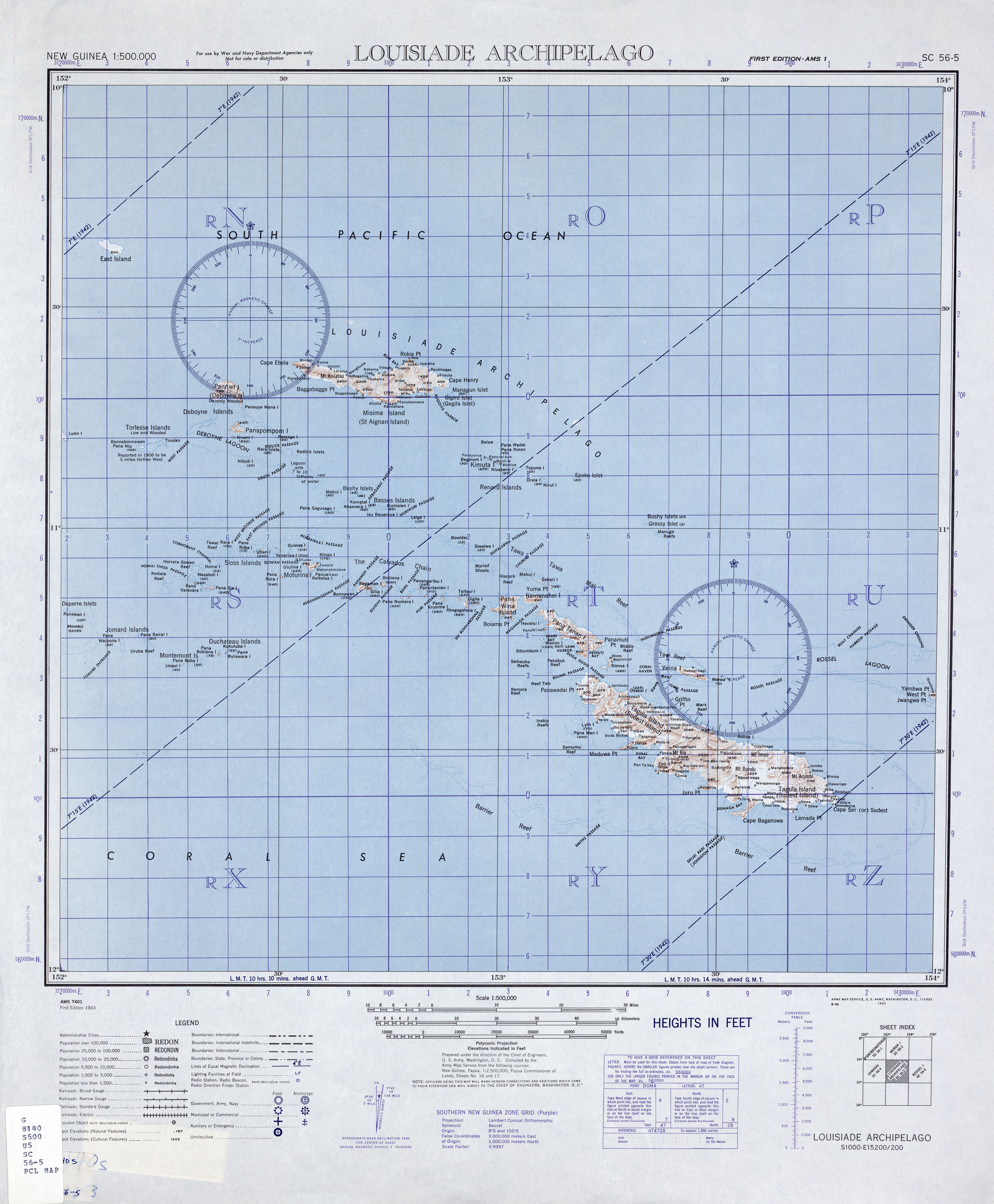
| Island name |
Alias |
Coordinates |
Area
km² |
Population
2000
|
|
Pana Vara Vara
|
Rugged Island
|
! 488.8794445652.302500511 ° 07 ′ S , 152 ° 18 ′ E-11.120555555556 152.3025
|
000000000000000.57000000000.57
|
0!-
|
|
Ehiki
|
|
! 488.9177785652.312500511 ° 05 ′ S , 152 ° 19 ′ E-11.082222222222 152.3125
|
000000000000000.05000000000.05
|
0!-
|
|
Nasakoli
|
|
! 488.8883335652.315278511 ° 07 ′ S , 152 ° 19 ′ E-11.111666666667 152.31527777778
|
000000000000000.01000000000.01
|
0!-
|
|
Panasia
|
Real Island
|
! 488.8666675652.332778511 ° 08 ′ S , 152 ° 20 ′ E-11.133333333333 152.33277777778
|
000000000000002.11000000002.11
|
0!-
|
|
No Ina
|
Burnett Island
|
! 488.9202785652.355278511 ° 05 ′ S , 152 ° 21 ′ E-11.079722222222 152.35527777778
|
000000000000000.13000000000.13
|
0!-
|
|
Rara
|
|
! 488.9602785652.383056511 ° 02 ′ S , 152 ° 23 ′ E-11.039722222222 152.38305555556
|
000000000000000.17000000000.17
|
0!-
|
|
Pana Roba
|
Sloss Island
|
! 488.9580565652.402222511 ° 03 ′ S , 152 ° 24 ′ E-11.041944444444 152.40222222222
|
000000000000000.19000000000.19
|
0!-
|
|
Utian
|
Brooker Island
|
! 488.9500005652.446667511 ° 03 ′ S , 152 ° 27 ′ E-11.05 152.44666666667
|
000000000000001.54000000001.54
|
391
|
|
Pana Udu Udi
|
|
! 488.9561115652.486389511 ° 03 ′ S , 152 ° 29 ′ E-11.043888888889 152.48638888889
|
000000000000000.69000000000.69
|
0!-
|
|
Pana Rora
|
Eddystone Island
|
! 488.8916675652.500833511 ° 06 ′ S , 152 ° 30 ′ E-11.108333333333 152.50083333333
|
000000000000000.81000000000.81
|
0!-
|
|
Toloi Awa
|
|
! 488.9505565652.497778511 ° 03 ′ S , 152 ° 30 ′ E-11.049444444444 152.49777777778
|
000000000000000.13000000000.13
|
0!-
|
|
Gulewa
|
|
! 488.9580565652.513333511 ° 03 ′ S , 152 ° 31 ′ E-11.041944444444 152.51333333333
|
000000000000000.59000000000.59
|
014!14th
|
|
Sibumbum
|
|
! 488.9713895652.518889511 ° 02 ′ S , 152 ° 31 ′ E-11.028611111111 152.51888888889
|
000000000000000.01000000000.01
|
0!-
|
|
Tobaiam
|
|
! 488.9480565652.515833511 ° 03 ′ S , 152 ° 31 ′ E-11.051944444444 152.51583333333
|
000000000000000.07000000000.07
|
0!-
|
|
Ululina
|
|
! 488.9183335652.538333511 ° 05 ′ S , 152 ° 32 ′ E-11.081666666667 152.53833333333
|
000000000000000.59000000000.59
|
0!-
|
|
Venariwa
|
Vanaliwa
|
! 488.9333335652.533611511 ° 04 ′ S , 152 ° 32 ′ E-11.066666666667 152.53361111111
|
000000000000000.76000000000.76
|
012!12
|
|
Saru Nom Nom
|
|
! 488.9666675652.546111511 ° 02 ′ S , 152 ° 33 ′ E-11.033333333333 152.54611111111
|
000000000000000.07000000000.07
|
0!-
|
|
Motorina
|
Mewstone Island
|
! 488.9152785652.571111511 ° 05 ′ S , 152 ° 34 ′ E-11.084722222222 152.57111111111
|
000000000000007.79000000007.79
|
577
|
|
Pana Tatoni
|
|
! 488.9611115652.560000511 ° 02 ′ S , 152 ° 34 ′ E-11.038888888889 152.56
|
000000000000000.04000000000.04
|
0!-
|
|
Ninan
|
|
! 488.9361115652.585833511 ° 04 ′ S , 152 ° 35 ′ E-11.063888888889 152.58583333333
|
000000000000000.18000000000.18
|
0!-
|
|
Panua Keikeisa
|
|
! 488.8994445652.607500511 ° 06 ′ S , 152 ° 36 ′ E-11.100555555556 152.6075
|
000000000000000.22000000000.22
|
0!-
|
|
Laiwan
|
|
! 488.8925005652.638056511 ° 06 ′ S , 152 ° 38 ′ E-11.1075 152.63805555556
|
000000000000000.15000000000.15
|
0!-
|
|
Bonna Wan
|
|
! 488.8691675652.658333511 ° 08 ′ S , 152 ° 39 ′ E-11.130833333333 152.65833333333
|
000000000000001.09000000001.09
|
0!-
|
|
Bagaman
|
Stanton Island
|
! 488.8675005652.689167511 ° 08 ′ S , 152 ° 41 ′ E-11.1325 152.68916666667
|
000000000000007.45000000007.45
|
201
|
|
Aurobu
|
|
! 488.8508335652.691667511 ° 09 ′ S , 152 ° 42 ′ E-11.149166666667 152.69166666667
|
000000000000000.05000000000.05
|
0!-
|
|
Gilia
|
|
! 488.8652785652.716667511 ° 08 ′ S , 152 ° 43 ′ E-11.134722222222 152.71666666667
|
000000000000000.36000000000.36
|
0!-
|
|
Bobiana
|
Huxley Island
|
! 488.8738895652.733056511 ° 08 ′ S , 152 ° 44 ′ E-11.126111111111 152.73305555556
|
000000000000002.43000000002.43
|
0!-
|
|
Leiga
|
|
! 488.8588895652.763333511 ° 08 ′ S , 152 ° 46 ′ E-11.141111111111 152.76333333333
|
000000000000000.05000000000.05
|
0!-
|
|
Mabneian
|
|
! 488.8777785652.760556511 ° 07 ′ S , 152 ° 46 ′ E-11.122222222222 152.76055555556
|
000000000000000.38000000000.38
|
0!-
|
|
Pana Cuba
|
|
! 488.8619445652.767778511 ° 08 ′ S , 152 ° 46 ′ E-11.138055555556 152.76777777778
|
000000000000000.10000000000.10
|
0!-
|
|
Pana Numara
|
Panaumara
|
! 488.8480565652.780833511 ° 09 ′ S , 152 ° 47 ′ E-11.151944444444 152.78083333333
|
000000000000001.93000000001.93
|
139
|
| (unnamed)
|
|
! 488.8569725652.791833511 ° 09 ′ S , 152 ° 48 ′ E-11.143027777778 152.79183333333
|
000000000000000.09000000000.09
|
0!-
|
|
Yaruman
|
|
! 488.8611115652.799444511 ° 08 ′ S , 152 ° 48 ′ E-11.138888888889 152.79944444444
|
000000000000000.37000000000.37
|
0!-
|
|
Nunuan
|
|
! 488.8569445652.814167511 ° 09 ′ S , 152 ° 49 ′ E-11.143055555556 152.81416666667
|
000000000000000.13000000000.13
|
0!-
|
|
Panangaribu
|
|
! 488.8647225652.811111511 ° 08 ′ S , 152 ° 49 ′ E-11.135277777778 152.81111111111
|
000000000000000.50000000000.50
|
0!-
|
|
Panantanian
|
Sharp Island
|
! 488.8477785652.826389511 ° 09 ′ S , 152 ° 50 ′ E-11.152222222222 152.82638888889
|
000000000000000.79000000000.79
|
0!-
|
|
Pana Krusima
|
Earle Island
|
! 488.8441675652.868056511 ° 09 ′ S , 152 ° 52 ′ E-11.155833333333 152.86805555556
|
000000000000001.47000000001.47
|
0!-
|
|
Einamu
|
|
! 488.8416675652.890833511 ° 09 ′ S , 152 ° 53 ′ E-11.158333333333 152.89083333333
|
000000000000000.05000000000.05
|
0!-
|
|
Taifaur
|
|
! 488.8455565652.901389511 ° 09 ′ S , 152 ° 54 ′ E-11.154444444444 152.90138888889
|
000000000000000.40000000000.40
|
0!-
|
|
Kuwanak
|
Kuanak, Abagagaheia
|
! 488.8291675652.915278511 ° 10 ′ S , 152 ° 55 ′ E-11.170833333333 152.91527777778
|
000000000000003.66000000003.66
|
129
|
|
Gigila
|
Nogui
|
! 488.8277785652.939722511 ° 10 ′ S , 152 ° 56 ′ E-11.172222222222 152.93972222222
|
000000000000001.42000000001.42
|
092!92
|
|
Waia
|
|
! 488.8250005652.950278511 ° 11 ′ S , 152 ° 57 ′ E-11.175 152.95027777778
|
000000000000000.08000000000.08
|
0!-
|
|
Yakimoan
|
|
! 488.8277785652.967500511 ° 10 ′ S , 152 ° 58 ′ E-11.172222222222 152.9675
|
000000000000000.31000000000.31
|
0!-
|
|
Pana Wina
|
Panawina, Kaluma
|
! 488.8194445653.007222511 ° 11 ′ S , 153 ° 00 ′ E-11.180555555556 153.00722222222
|
000000000000030.550000000030.55
|
347
|
|
Hemenahei
|
|
! 488.8416675653.071389511 ° 09 ′ S , 153 ° 04 ′ E-11.158333333333 153.07138888889
|
000000000000010.240000000010.24
|
0!-
|

.JPG)

