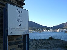
Camí de Ronda
The Camí de Ronda (Spanish: Camino de Ronda ) is a coastal hiking trail on the Costa Brava in Spain and connects the Catalan towns of Portbou south of the French border and Blanes . It is part of the Spanish long-distance hiking trail GR-92 (Spanish: Gran Recorrido 92 , Catalan: Gran Recorregut 92 ) and has a length of almost 200 km.
history
Fishermen used the coastal paths along the Mediterranean coast centuries ago to reach bays and neighboring towns by land. From the middle of the 19th century, these coastal paths were used by the Spanish Guardia Civil as a control path to keep an eye out for smugglers and to prevent their activities. In the middle of the 20th century, these paths lost their importance, but experienced a renewed boom from the 1960s onwards with tourism on the Costa Brava.
route
The Camí de Ronda begins south of the French border at Portbou, leads through the Cap de Creus Nature Park with the villages of El Port de la Selva , Cadaqués to Roses , continues to L'Escala , Torroella de Montgri , Begur , Palamós , Sant Feliu de Guixols , Tossa de Mar and ends in Blanes.
bibliography
- Roger Büdeler: Rother hiking guide Costa Brava . Bergverlag Rother, Oberhaching 2012, ISBN 978-3-7633-4328-7 .
