
Cap de Creus


The Cap de Creus [ ˈkab də ˈkɾɛws ] ( Spanish Cabo de Creus ) in Catalonia forms the easternmost point of the Iberian Peninsula . It is located on a peninsula that extends over 10 km into the Mediterranean Sea . Here the foothills of the Pyrenees fall into the Mediterranean, with the highest point on the peninsula, the Sant Salvador Saverdera, rising 670 m above sea level. The Cap de Creus forms the northern limit of the Gulf of Roses on the northern Costa Brava , it borders Roses and El Port de la Selva and includes the localities of Cadaqués and Port Lligat .
Cap de Creus Natural Park

The Cap de Creus peninsula was declared a Natural Park by Law 4/1998 for the protection of the Cap de Creus in 1998 . The total area of the nature park is 13,886 hectares, with 3,073 hectares of water and 10,813 hectares of land being protected. The protected lake area includes the areas of Cap Gros , Punta de Cap de Creus and Cap Norfeu .
The medieval monastery of Sant Pere de Rodes is located in the Cap de Creus natural park and houses an information center about the natural park.
geology
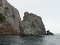
The landscape at Cap de Creus is shaped by the erosion of the Tramuntana winds, so that bizarre rock formations have emerged in some places. The rock consists of pegmatite , migmatite and shale .

Rocks made of quartzite (light) and taphoned, metamorphic slate 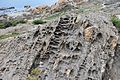
Tafonis in metamorphic slates 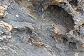
Migmatite: The light-colored, melted rock components (leukosome) show an intense fold (ptygmatization). 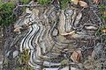
Quartzite with a migmatitic structure and individual boudinated layers 
A boudin 
Ptygmatic folds in a migmatite


Zoomorphism and Surrealism
Wind and rain have given the exposed rocks in the nature park unusual shapes. Some special formations have been associated with animal figures, have been given corresponding names and are marked with images on metal plates along the main path through the park.

S'àguila de Tudela
(The Eagle of Tudela)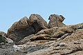
El camell de Tudela
(The Camel of Tudela)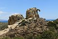
Es camell
(the camel)
Es conill de Culip
(The Rabbit of Tulip)
La foca
(The Seal)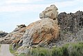
El goril la
(The Gorilla)
La llebre de Cala Culip
(The Rabbit of Cala Culip)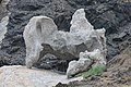
El gran masturbador
(The large masturbator, so named by Dalí)


Salvador Dalí , the surrealist artist who lived in a house nearby and had his studio there, was inspired by a rock formation for the dissolving form in the painting El gran masturbador . Dalí found the following words for this part of the Cap de Creus:
“Aquesta part compresa entre el Camell I l'Àguila que tu coneixes i estimes tant com jo mateix és i ha de continuar per semper sent geologia pura, sense res que pugui mitificar-lo, ho faig una qüestió de principis. És un paratge mitològic que es fet per Déus més que per a Homes i cal que continuï tal com està. "
“(Loosely translated) This part between the camel and the eagle, which you know and love as much as I do, is and should remain pure geology forever, with nothing to damage it; it is a matter of principle. This is a mythological place, made more for the gods than for humans and it should remain so. "
Flora and fauna
Cap de Creus grow endemic plant species such as the beach lilac ( Limonium geronense ). Tree milkweed and thorn tragacanth as well as neptune grass as aquatic plants, thistles, cacti and other typical coastal plants of the Mediterranean region also grow on the Cape .
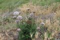
Wild carrot ( Daucus carota subsp. Hispanicus ) 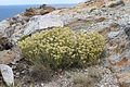
Everlasting flower ( helichrysum ) 
Sea fennel ( Crithmum maritimum ) 
Ruthenian globe thistle ( Echinops ritro ) 
Opuntia ( Opuntia ficus-indica )


The animals living here include the Mediterranean tree frog ( Hyla meridionalis ), the Mediterranean wheatear ( Oenanthe hispanica ), the shag ( Phalacrocorax aristotelis ) and the grouper ( Epinephelus guaza ).
lighthouse

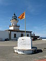
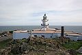
The tip of the cape is the Punta de Cap de Creus with a lighthouse . It was inaugurated in 1853 and is 78 m above sea level and shines 34 nautical miles .
Next to the lighthouse is a former police barracks, which was used for maritime border surveillance. Today there is a restaurant in this building.
A notice board from the city administration of Cadaqués reminds that at the headland of Sa Punta de sa Clavaguera , below the lighthouse, a hexagonal lighthouse was built in July 1970 especially for the shooting of the film The Light at the End of the World , which was only demolished in November 1998 has been.
activities
The Cap der Creus Natural Park is a popular area for hiking . This is where the GR 11 long-distance hiking trail begins , which runs across the Pyrenees to the Atlantic coast . The GR 92.1 hiking trail leads from Palau-saverdera through all villages to the Cape .
The lake area at Cap de Creus is a popular diving area among scuba divers . Due to the rocky landscape, most of the dive sites are approached by boats from Cadaqués , Roses , El Port de la Selva or Port Lligat , and entry from land is only possible in a few places.
gallery

Sign board

lighthouse
Lighthouse and Catalan flag

Rocky coast on the Cap
lighthouse
West side of the El Gat rock on Cap Norfeu


Web links
Individual evidence
- ^ Roger Büdeler: Rother hiking guide Costa Brava . Bergverlag Rother, ISBN 978-3-7633-4328-7 , pp. 68 to 69.
- ↑ Cristina Masanes Casaponsa, Susanne Engler: Cadaqués . Triangle Postals, 2004, ISBN 84-8478-141-0 , p. 129.
- ↑ Cristina Masanes Casaponsa, Susanne Engler: Cadaqués . Triangle Postals, 2004, ISBN 84-8478-141-0 , p. 130.
- ↑ Jordi Carreras and Elena Druguet: Illustrated Field Guide to the Geology of Cao de Creus
- ↑ Information about the lighthouse (span.)
- ↑ The lighthouse in GoogleMaps
- ↑ Difficult paradise . In: mare . No. 55, Mareverlag 2006, p. 104.
Coordinates: 42 ° 19 ′ 9.4 ″ N , 3 ° 19 ′ 19.5 ″ E