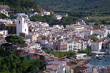
El Port de la Selva
| El Port de la Selva municipality | ||
|---|---|---|

|
||
| coat of arms | Map of Spain | |

|
|
|
| Basic data | ||
| Autonomous Community : | Catalonia | |
| Province : | Girona | |
| Comarca : | Alt Empordà | |
| Coordinates | 42 ° 20 ′ N , 3 ° 12 ′ E | |
| Height : | 12 msnm | |
| Area : | 42 km² | |
| Residents : | 970 (Jan. 1, 2019) | |
| Population density : | 23.1 inhabitants / km² | |
| Municipality number ( INE ): | 17140 | |
| administration | ||
| Official language : | Castilian , Catalan | |
| Mayor : | Josep Maria Cervera | |
| Website : | www.elportdelaselva.cat | |
El Port de la Selva [ əɫ ˈpɔr ðə ɫə sɛɫβə ] is a coastal town with 970 inhabitants (as of January 1, 2019) in the autonomous region of Catalonia ( Spain ). The municipality is located on the Golfe du Lion on the Costa Brava on the border with the Parc Natural del Cap de Creus .
Population development
| Population development | |
|---|---|
| year | Residents |
| 1900 | 1441 |
| 1930 | 1050 |
| 1950 | 901 |
| 1970 | 958 |
| 1986 | 768 |
| 2001 | 760 |
| 2006 | 908 |
| 2010 | 993 |
Attractions
Within the municipal boundaries of El Port de la Selva are the following culturally and historically significant sights:
- Church Mare de Deu de les Neus
- Dolmen of Mores Altes
- Paradolms de la Pallera
- Remains of the Santa Creu de Rodes settlement
- Romanesque hermitage of Santa Helena
- Castle ruins of Sant Salvador de Verdera
- Benedictine monastery of Sant Pere de Rodes
- Romanesque church ruins of Sant Baldiri de Taballera
gallery
Web links
Commons : El Port de la Selva - collection of images, videos and audio files
- Topographic map and data of the Generalitat at El Port de la Selva
- Port de la Selva, presented by CapCreus online (German)
- Photos and descriptions of objects of interest in El Port de la Selva
Individual evidence
- ↑ Cifras oficiales de población resultantes de la revisión del Padrón municipal a 1 de enero . Population statistics from the Instituto Nacional de Estadística (population update).
- ↑ El Port de la Selva. In: poblesdecatalunya.cat


