
Maçanet de Cabrenys
| Maçanet de Cabrenys municipality | |||
|---|---|---|---|
 Bell tower of the Sant Martí Church
|
|||
| coat of arms | Map of Spain | ||

|
|
||
| Basic data | |||
| Autonomous Community : | Catalonia | ||
| Province : | Girona | ||
| Comarca : | Alt Empordà | ||
| Coordinates | 42 ° 23 ' N , 2 ° 45' E | ||
| Height : | 370 msnm | ||
| Area : | 67.88 km² | ||
| Residents : | 688 (Jan. 1, 2019) | ||
| Population density : | 10.14 inhabitants / km² | ||
| Postal code : | 17720 | ||
| Municipality number ( INE ): | 17102 | ||
| administration | |||
| Official language : | Castilian , Catalan | ||
| Mayor : | Lluís Carbó Saguer | ||
| Website : | www.ddgi.cat/cabrenys | ||

Maçanet de Cabrenys is a Spanish municipality in the comarca of Alt Empordà in Catalonia .
geography
Maçanet de Cabrenys lies at the foot of the eastern foothills of the Pyrenees . The Arnera and Rinadal rivers, as well as the GR-11 trekking trail, cross the area. In the south and southeast it borders the municipalities of Albanyà and Sant Llorenç de la Muga , in the east on the municipalities of La Vajol and Darnius and in the north on Costoja, Sant Llorenç de Cerdans, Reiners, Els Banys d'Arles, Palaldà, Céret , Morellàs and Les Illes.
Community structure
The municipality consists of the following districts:
- Arnera
- Les Creus
- Maçanet de Cabrenys
- Les Mines
- Les Salines
- Tapis
- Els Vilars
- Oliveda
Population development
| year | 1717 | 1787 | 1857 | 1887 | 1910 | 1920 | 1930 | 1940 | 1950 | 1960 | 1970 | 1981 | 1990 | 2000 | 2009 |
|---|---|---|---|---|---|---|---|---|---|---|---|---|---|---|---|
| Residents | 453 | 1,484 | 1,832 | 1,609 | 1,641 | 1,537 | 1,273 | 1,061 | 1,134 | 926 | 872 | 800 | 718 | 664 | 729 |
history

In the last century Neolithic axes were found near the Arnera River , as well as the Menhir de la Pedra Dreta ('Menhir of the standing stone'). They show that the Arnera Valley has been populated since prehistoric times. The first written mention of the name Maçanet was found in a document from King Louis the Pious from the year 814, in which it was written that Maçanet is south of Céret - " villam quae dicitur Macanetum " .
In 954, Landgrave Guifré II of Besalú donated a piece of land to the monastery of Sant Pere de Camprodon , which belonged to the municipality of Tapis, to build the church of Mare de Déu de les Salines ('Church of the Mother of God of the Salt Mines'). In 1440 de Cabrenys was added to the place name Maçanet, as this parish belonged to the County of Cabrenys. The Cabrenys descended from the influential Rocabertí family . In 1553 half of the population fell victim to the black plague. In July 1675, Lieutenant General Le Bret and 1500 soldiers looted the place.
economy
Originally, in addition to traditional agriculture, there were some textile and iron industries as well as bottle cork factories and a large pipe factory in the community. Today the main income of the municipality is achieved with tourism and the construction industry. Spring water belonging to the mineral water company Vichy Catalán is bottled from the Font de les Creus ('Source of Crosses') .
Architectural monuments
Església de Sant Martí
The Església de Sant Martí (Church of St. Martin), from the 12th or 13th century, is part of late Romanesque art. It consists of a single rectangular hall with a curved vault and a semicircular apse . The entrance area is formed by four stone arches that form a semicircle. The entrance gate itself is made of wood and decorated with iron figures from the medieval period.

Facade of the church
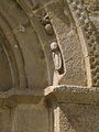
Section of the gate

Church chapel

apse


Capella de Sant Sebastià
The Capella de sant Sebastià ('Chapel of Saint Sebastian') was built at the end of the 16th century after the outbreak of the black plague. The chapel was renovated in the 18th century.

Chapel facade

Interior of the chapel

Altar area


Santuari de Les Salines
The Santuari de la Mare de Déu de les Salines ('Sanctuary of the Mother of God of the Salt Mines') lies below a 1,100-meter-high mountain peak that bears the same name. The Santuari is 15 kilometers from the village, it was built in 1271 and renovated in the 18th century.

Facade of the church of the salt mine
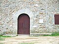
Church gate of the salt mine

The three-ray fountain at the church of the salt mine


Roland's hammer
In 1834 the so-called "Hammer of Roland ", the Carolingian knight, was immortalized right in the middle of the parish square. It is a massive iron rod more than five meters high. The ring at the top used to serve as a lamp holder. Roland's hammer was made in an old iron foundry near the Arnera River. Legend has it that Roland himself threw the hammer from the bridge in Ceret. Another legend says that Roland threw the hammer from Cabrenys Castle in Vallespir and said: "Wherever the hammer falls, Maçanet by Cabrenys should be built".
The standing stone
The standing stone is a menhir , which the locals call La Pedra dreta ('The standing stone'). It is located two kilometers from the village.
Tapis

Tapis is a small village that belongs to the municipality of Maçanet de Cabrenys. The name Tapis was first mentioned in a record in 954. In 2005 the village had only 25 inhabitants.
Sant Briç
The Church of Saint Briç in Tapis was built at the end of the 12th or beginning of the 13th century. At the end of the inner church hall there are two small chapels that form a cross with the large hall. The altar area at the end of the hall is connected by an almond-shaped double arch. The narrow arches, the proportions, the style and the structure of the column ends of the entrance gate are typical features of the last phase of Romanesque art in Catalonia.

Saint Briç Church

Bell tower

Church arch

Church gate


Mountains at Maçanet de Cabrenys
|
|
|
Stationary
The local festival of Maçanet de Cabrenys is celebrated on the first Sunday in July and the festival of Saint Martin of Tours , patron saint of the municipality, on November 11th .
Web links
- Official website
- The Great War in Maçanet
- Administration of Salines-Bassegoda
- Information about the Catalan Government (Generalitat de Catalunya)
- Catalan Institute of Statistics
- Articles and pictures from Maçanet de Cabrenys
Individual evidence
- ↑ Cifras oficiales de población resultantes de la revisión del Padrón municipal a 1 de enero . Population statistics from the Instituto Nacional de Estadística (population update).
- ^ David Steward: Assimilation and acculturation in seventeenth-century Europe: Roussillon and France 1659-1715 . ( Online in Google Book Search).

Agullana | Albanyà | L'Armentera | Avinyonet de Puigventós | Biure | Boadella d'Empordà | Borrassà | Bàscara | Cabanelles | Cabanes | Cadaqués | Cantallops | Capmany | Castelló d'Empúries | Cistella | Colera | Darnius | L'Escala | Espolla | El Far d'Empordà | Figueres | Fortià | Garriguella | Garrigàs | La Jonquera | Lladó | Llançà | Llers | Masarac | Maçanet de Cabrenys | Mollet de Peralada | Navata | Ordis | Palau de Santa Eulàlia | Palau-saverdera | Pau | Pedret i Marzà | Peralada | Pont de Molins | Pontós | El Port de la Selva | Portbou | Rabós | Riumors | Roses | Sant Climent Sescebes | Sant Llorenç de la Muga | Sant Miquel de Fluvià | Sant Mori | Sant Pere Pescador | Santa Llogaia d'Àlguema | Booze | La Selva de Mar | Siurana | Terrades | Torroella de Fluvià | La Vajol | Ventalló | Vila-sacra | Vilabertran | Viladamat | Vilafant | Vilajuïga | Vilamacolum | Vilamalla | Vilamaniscle | Vilanant | Vilaür