Vilabertran
| Vilabertran municipality | ||
|---|---|---|
| coat of arms | Map of Spain | |

|
|
|
| Basic data | ||
| Autonomous Community : | Catalonia | |
| Province : | Girona | |
| Comarca : | Alt Empordà | |
| Coordinates | 42 ° 17 ′ N , 2 ° 59 ′ E | |
| Height : | 19 msnm | |
| Area : | 2.29 km² | |
| Residents : | 979 (Jan 1, 2019) | |
| Population density : | 427.51 inhabitants / km² | |
| Municipality number ( INE ): | 17214 | |
| administration | ||
| Official language : | Castilian , Catalan | |
| Mayor : | Martí Armadà i Pujol | |
| Website : | www.vilabertran.com | |

The municipality of Vilabertran is located in the autonomous region of Catalonia . It belongs to the province of Girona in northeastern Spain and is part of the Comarca Alt Empordà . It borders directly on Figueres and is in turn bounded by the course of the La Muga rivers in the north and the Manol in the south.
history
The village was built around the monastery of Santa Maria de Vilabertran , an important Augustinian abbey that existed until 1835.
politics
The 2007 local elections resulted in the following distribution of seats in the local council:
- Esquerra-AM : 6 seats
- PSC-PM : 1 seat
economy
Part of the population lives from agriculture, which mainly produces vegetables for the market in Figueres and the surrounding communities. The water required for this is channeled from the Boadella reservoir to Vilabertrans fields.
Attractions
- Monestir de Santa Maria de Vilabertran. Romanesque monastery from the 11th century.
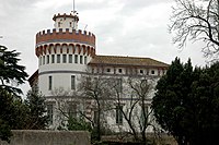
- Torre d'en Reig. Art Nouveau tower from the 19th century, today the seat of the municipal administration.
Web links
- Topographic map and data of the Generalitat at Vilabertran
- Informació de l'Institut d'Estadística de Catalunya
Individual evidence
- ↑ Cifras oficiales de población resultantes de la revisión del Padrón municipal a 1 de enero . Population statistics from the Instituto Nacional de Estadística (population update).


