
Sant Feliu de Guíxols
| Municipality of Sant Feliu de Guíxols | |||
|---|---|---|---|
 The Nou Casino ('New Casino') in Sant Feliu de Guíxols
|
|||
| coat of arms | Map of Spain | ||

|
|
||
| Basic data | |||
| Autonomous Community : | Catalonia | ||
| Province : | Girona | ||
| Comarca : | Baix Empordà | ||
| Coordinates | 41 ° 47 ' N , 3 ° 2' E | ||
| Height : | 4 msnm | ||
| Area : | 16.23 km² | ||
| Residents : | 21,925 (Jan. 1, 2019) | ||
| Population density : | 1,350.89 inhabitants / km² | ||
| Municipality number ( INE ): | 17160 | ||
| administration | |||
| Official language : | Castilian , Catalan | ||
| Mayor : | Miquel Lobato Cárdenas | ||
| Website : | www.guixols.net | ||
| Location of the municipality | |||

|
|||

Sant Feliu de Guíxols ( Catalan [ ˈsam fəˈɫiw ðə ˈɣiʃuɫs ]) is a Catalan city on the Costa Brava in the province of Girona . The name of Sant Feliu goes back to Saint Felix of Africa , legionary in the army of Maximian , who according to legend 304 in Lodi with Nabor the martyrdom suffered. The addition de Guíxols comes from the hills on which the ancient predecessor settlement was located; the etymology of this designation has not been established.
Landscape, location and surroundings

The coast of the Baix Empordà ends in Sant Feliu de Guíxols , and the Comarca La Selva begins to the south . Sant Feliu is located in a bay about 115 km northeast of Barcelona and is surrounded by hills and rocky coastal mountains. The natural boundaries through the steep coast meant that the city expanded very strongly inland in the form of an acute-angled triangle. As in the entire Baix Empordà, the vegetation around Sant Feliu is characterized by cork oak , pine and pine forests between the rocky coasts. Small beach bays lie between the cliffs. The largest nature reserve is the national park in the Gavarres Mountains, which is one of the Pla d'Espais d'Interès Natural (= PEIN) areas legally designated by the Catalan government on December 14, 1992 .
climate
As with all places on the eastern coast of Spain, the temperate climate of Sant Felius is characterized by the Mediterranean. The average annual temperature is 16 ° C, and winter is also quite mild. During the year the sun shines for approx. 2500 hours, rainfall is mostly in autumn and spring.
history


According to excavations, there was on the hills above the present-day city - now called Fortim or Salvament - around 400 BC. A first permanent settlement of the Iberians . This people was Romanized and Christianized in late antiquity. A continuity of this settlement has not been proven.
The foundation of the Benedictine monastery of Sant Feliu in the 10th century, which gradually attracted settlers, can therefore presumably be seen independently of the ancient foundation. The monastery exercised feudal rule in the region, which it formally held until 1835 (the abolition of all Benedictine monasteries in Spain). Remains of the church ( Plaça del Monestir ) as well as the Porta Ferrada and the towers del Fum and del Corn, which belong to the former medieval city fortifications, are still visible today .
In the course of the Middle Ages, the city growing around the monastery developed an increasing independence from feudal rule due to its economic importance. The port and shipyards were built as early as the 12th century. Sant Feliu grew in prosperity and size in the 14th century, when the place was raised to the rank of “ Carrer ” of Girona and thus received city privileges. This lived primarily from fishing and from branches of industry connected with fishing (fish conservation through salting, net weaving, boat building).
In the second half of the 18th century and in the 19th century, the cork industry outstripped fishing as the main source of income; Sant Feliu became the main international port of export for the raw material obtained in the nearby cork oak forests. On the other hand, many people who found no place in the cork industry emigrated to America during this period .
Towards the end of the 19th century the city expanded considerably and gained in architectural quality; According to plans by General Guitart i Lostaló , industrial stately villas were built along the beach promenade ( Passeig ), of which some characteristic examples are still preserved today ( Casino dels Nois , Casa Patxot , Can Sibils ).
The construction of a narrow-gauge railway in the years 1889 to 1892 by the architects Rafael Coderich and Gabriel March increased the importance of Sant Felius as a trading port, as goods from the inland could now also be transported via Girona for loading. After the initial distrust of the local wagoners and coachmen out of concern for their jobs and attempts at sabotage, the fast means of transport, which also served to transport people, was accepted over time.
With the new connection and increasing trade, Sant Feliu took the place of the second most important city in the Empordà after Palafrugell .
The rise of Sant Felius as a tourist center began in the second half of the 20th century. In contrast to those centers on the Costa Brava that the building boom of the 1960s and 1970s opened up for package tourism, Sant Feliu remained geared towards moderate visitor numbers in the expansion of its accommodation and dining facilities.
Cityscape

Sant Feliu de Guíxols is a city with a rich cultural, historical and architectural heritage. The cityscape is characterized by the typical architecture of a Catalan port city, which mixes with contemporary architecture. Numerous buildings have been renovated and restored.
There are two smaller Ramblas , Antoni Vidal and del Portalet , from which smaller alleys branch off. On the Ramblas you will find some shops, including small souvenir and tourist shops, but also tobacco shops and supermarkets. The Rambla del Portalet, whose construction was begun in 1833 with the participation of citizens, shares the beach promenade in two halves, the eastern is Passeig dels Guíxols and the western Passeig del Mar called.
This area along the harbor (large marina and fishing port) and city beach is lined with a small park with a promenade and restaurants. The central parking lot is also located here; the city center is largely closed to traffic.
Infrastructure

traffic
Connecting roads
Sant Feliu is well connected with other places and there are numerous ways to get to the place. The C-253 road runs north along the coast to Castell-Platja d'Aro and Palamós . The A-19 connects Sant Feliu with Barcelona .
The panoramic road to Tossa de Mar is a tourist route.
bus and train
The former narrow-gauge railway that ran between Sant Feliu and Girona was closed in 1969. Only the station building, which has been converted into a school, is preserved.
After the abolition of the narrow-gauge railway, Sant Feliu no longer has a direct rail link; the next train station is about 30 km away in Girona . There is a bus station in the city.
economy
The economy consists mainly of service industries, trade, fishing and tourism.
Tourism and sport


Unlike many other cities on the Costa Brava , tourism is not the preferred source of income. However, the stable tourism industry improves the economic situation. The city has several hotels, holiday apartments, campsites, cafes and restaurants.
Sant Feliu is not a concise center of beach tourism on the Costa Brava. In addition to the only 400 m long and 30 m wide city beach ( Platja Sant Feliu ), which is bounded by the rocky coast in the southwest on the one hand and the port facility in the northeast on the other, there is also the coarse sandy, sometimes stony, about 1.5 km northeast of the city center Platja Sant Pol (870 m long and 20 m wide). In addition to tourists, the beaches are also frequented by residents of the surrounding cities, who either have their holiday homes here or come to Sant Feliu for a short vacation.
Visitors appreciate the cultural sights of the municipality and use the place as a starting point for the coastal road to Tossa de Mar , which is one of the most attractive scenic roads on the Costa Brava.
Services for water sports, diving, mini golf , tennis and horse riding are available. The nearest golf course is about 10 km northeast at Platja d'Aro.
Today there is a 42 km long cycle route from Sant Feliu to Girona on the narrow-gauge line Ruta del Carrilet ; The mostly slightly downhill route leads through forest and field landscapes.
Fishing and cork industries
The historical branches of the Sant Felius economy - fishing and the cork industry - are still active in the 21st century.
The city still has a considerable fishing fleet and its own port.
As in the past, Sant Feliu is still the main port of export for the local cork industry. The high quality cork from Catalan and Andalusian cork oaks is exported worldwide by Sant Feliu.
population

Demographics
There are currently around 10,259 men and around 10,059 women living in Sant Feliu. The population has been rising steadily since the 1990s.
| 1900 | 1930 | 1950 | 1970 | 1986 | 1991 | 1996 | 2001 | 2004 | 2005 |
|---|---|---|---|---|---|---|---|---|---|
| 11,333 | 9,082 | 8,306 | 12,508 | 19,456 | 16.051 | 17,779 | 17,994 | 19,693 | 20,318 |
Culture


Attractions
The medieval complex
The nucleus of medieval Sant Feliu is the area around today's Plaça del Monestir . Here the city wall, of which the semicircular Torre del Fum and another square tower stump ( Torre del Corn ) once formed a unit with the Benedictine monastery church as a fortified church. The first building from 10/11. Century is largely destroyed.
- In 1931 the Porta Ferrada , a Romanesque three-axis portico with three large arcades on the basement and three triforias on the upper floor, was completed by a round arch frieze. This is where the entrance to the 14th century Gothic church was originally located on a cruciform floor plan with cross vaults and three apses, which is now accessed from the north transept. The interior includes a Romanesque crucifix from Navarre and a copy of the Montserrat Madonna statue .
- Isolated from the monastery church stands a baroque portal from 1747, which was one of the monastery buildings that were otherwise demolished; This Arc de Sant Benet (= Benedict Arch) with Ionic columns, city arms, flame vases and volute gable lost its statue of Saint Benedict in an arcade niche during the Spanish Civil War in 1936 . The replacement figure was designed in 1999 by Domenec Fita , a sculptor from Girona.
- The Municipal Museum ( Museu Municipal ) is also located on the monastery square with archaeological finds from Iberian, Roman and medieval times as well as exhibits on the city's history, in particular on seafaring and the cork industry.
The 19th and early 20th centuries
The casino and some mansions that local entrepreneurs built are testimony to the wealth of the cork industry during this period.
- One of the most beautiful Art Nouveau buildings in the city is the Casino dels Nois , built by General Guitart in 1888 , which is still used as a casino in the 21st century. In addition to this function, the area around the casino also fulfills a social role as a meeting point for the urban population, especially for the older residents on the promenade under the shade of the plane trees.
- The Art Nouveau villa Casa Patxot on the promenade was built between 1917 and 1920 by the cork entrepreneur Rafael Patxot by the architect Alber Juan i Torner. Patxot maintained an astronomical observation station there during his lifetime. The gable fresco from 1920 with an integrated sundial is a reminder of this. Today the building is the seat of the local Chamber of Commerce and Industry.
- Other industrial villas from this era ( cases senyorials ) are the Casa Albertí (late 19th century), the Casa de la Campana (1911), the Casa Gaziel (1880), the Casa Girbau (191), the Casa Maynegre ( 1898), Casa Maruny (1909), Casa Pecher (1894), Casa Ribot (1904), Casa Sala (1904) and Casa Sibils (1892).
- The market hall (1929) built by Joan Bordàs is located on the Plaça del Mercat , where the weekly market starts in the early morning hours every Sunday. The core of this marketplace was laid out in the Middle Ages (mentioned in the 13th century); however, its original structure can no longer be traced. The town hall from 1547 has late Gothic and Renaissance style elements. It is flanked by a clock tower from 1847 and was rebuilt and expanded after being destroyed in the war in the 1940s and 1950s.
- The sea rescue museum established in 1889 on the hill at the eastern end of the bay is also built in Art Nouveau style. It is located in a small pine grove and has a terrace with a beautiful view of the coast. Various equipment that was used in sea rescue is shown, as well as some documents and pictures.
- The Museum of the History of Toys documents 2,500 exhibits from the 19th and 20th centuries.

market

Marketplace

Maritime Rescue Museum
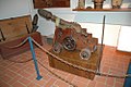
Maritime Rescue Museum


Sights outside the city

- A few kilometers northeast of Sant Feliu, an approx. 5 km long asphalt road leads from the main road to Girona near the Blamanya campsite, past some barbecue areas to the Pedralta , a rocking stone made of granite . Its name is derived from pedra sobre l'altre pedra (for “one stone above the other”). The Pedralta (6 m long, 4 m wide and 3.5 m high) weighs 33 tons and is the second largest rocking stone in Europe after the one at Solla in Bavaria with 50 tons. In 1996 the stone fell down; Suspected outside influence by a drunk was discussed but could not be proven. After a long discussion about the costs involved, the stone was raised again, but its ability to rock was lost.
- On the 99 m high Puig i Castellar, southwest of the city, is the small chapel Eremita de Sant Elm , which was built in 1723 in honor of St. Telmo and Our Lady of the Good Voyage, the patron saints of sailors, pilgrims and seafarers. From here you have a very good view of the city and the rocky coast. There is a memorial stone in honor of the writer and journalist Ferran Agulló .
- The 13 km long panoramic road to Tossa de Mar connects to the south-west through a rugged rock landscape in the middle of holm oak and pine forests high above small sandy bays with holiday apartment settlements and campsites. The road runs in hairpin bends close to the edge of the cliff; several parking bays offer viewpoints ( miradores ) of the bizarre landscape, which Ferran Agulló supposedly had in mind when he named the 220 km long Mediterranean coast between the French border and Barcelona in 1908 the name Costa Brava ("wild coast").
Festivals and traditions
El Carneval takes place between February and March ; as in almost all larger cities, there are moves.
As in many Catalan towns, St. George is celebrated on April 23rd . There are parades, sardanas and public meals.
The Porta Ferrada International Music Festival (Festival Internacional de la Porta Ferrada) takes place every year from July to August . It was first held in 1962 and is considered the oldest music festival in Catalonia .
During the Mostra de Canço de Taverna , the restaurants and squares are dedicated to the music of fishermen and workers.
The Festes Majors are celebrated in all Catalan towns and serve to honor the village saints. The feast day for the local saint Felix of Africa is July 12th. With regard to the holiday season, the 4-day patronage festival with dances, fireworks, sporting and cultural competitions takes place from August 1st to 4th.
On September 11th the national holiday Diada Nacional de Catalunya takes place in Sant Feliu as in all of Catalonia with parades and sardanas .
gallery

Sant Feliu fishing port

View from the Sant Elm monastery

Part of the port, in the background the Maritime Rescue Museum

Park next to the beach boulevard

graveyard


Twin cities

|
|
The town partnership with the Bavarian town of Mindelheim came into being through the joint French twin town of Bourg-de-Péage.
Personalities
- Ferran Agulló (1863–1933), journalist and writer, namesake of the Costa Brava (1908)
- Juli Garreta i Arboix (1875–1925), Sardana composer and journalist
- Josep Irla i Bosch (1876–1958), Catalan politician
- Josep Maria Vilà i Gandol (1904–1937), Sardana composer
- Casa Albertí (1913–1993) was an artist and painted many pictures of Sant Feliu, some of which can be seen in the Museu d'Història Casa Albertí.
literature
- Baedeker travel guide Costa Brava. Verlag Karl Baedeker, 4th edition 2000
Web links
- Sant Feliu de Guíxols in German from CapCreus online
- Official city site of Sant Feliu de Guíxols
- Pedralta
- City map ( PDF file; 5 kB)
Individual evidence
- ↑ Cifras oficiales de población resultantes de la revisión del Padrón municipal a 1 de enero . Population statistics from the Instituto Nacional de Estadística (population update).
Albons | Begur | Bellcaire d'Empordà | La Bisbal d'Empordà | Calonge | Castell-Platja d'Aro | Colomers | Corçà | Cruïlles, Monells i Sant Sadurní de l'Heura | Foixà | Fontanilles | Forallac | Garrigoles | Gualta | Jafre | Mont-ras | Palafrugell | Palamós | Palau-sator | Pals | Parlavà | La Pera | Regencós | Rupià | Sant Feliu de Guíxols | Santa Cristina d'Aro | Serra de Daró | La Tallada d'Empordà | Torrent | Torroella de Montgrí | Ullastret | Ullà | Ultramort | Vall-llobrega | Verges | Vilopriu