Campbelltown City, New South Wales
| City of Campbelltown | |
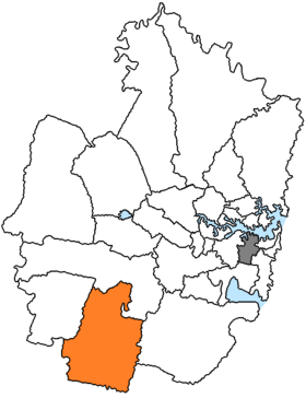
 Location of Campbelltown City in Sydney |
|
| structure | |
| State : |
|
| State : |
|
| Administrative headquarters: | Campbelltown |
| Dates and numbers | |
| Area : | 311.9 km² |
| Residents : | 157.006 (2016) |
| Population density : | 503 inhabitants per km² |
Coordinates: 34 ° 4 ′ S , 150 ° 49 ′ E Campbelltown City is a local government area (LGA) in the Australian state of New South Wales . Campbelltown belongs to the metropolis of Sydney , the capital of New South Wales. The area is 311.9 km² and has about 157,000 inhabitants.
location
Campbelltown is located about 43 kilometers from the city center on the south-western outskirts of Sydney.
administration
The area is divided into the 45 districts of Airds, Ambarvale, Blair Athol, Blairmount, Bow Bowing, Bradbury, Campbelltown, East Campbelltown, Campbelltown North, Claymore, Eagle Vale, Englorie Park, Eschol Park, Gilead, Glen Alpine, Glenfield, Glenlee, Glenquarie, Kearns, Kentlyn, Leumeah, Leumeah Heights, Long Point, Macarthur Square, Macquarie Fields, Macquarie Heights, Macquarie Links, Manaluka, Maryfields, Menangle Park, Minto, Minto Heights, Raby, Rosemeadow, Ruse, Sherwood Hills, St Andrews, St Helens Park, Varroville, Wederburn, Woodbine and portions of Denham Court, Ingleburn, Ingleburn Military Camp and Leppington.
The council's headquarters are in Campbelltown, west of the LGA.
The Campbelltown City Council has 15 members who are elected by LGA residents. Campbelltown is not divided into districts. The mayor of the council is also recruited from among the councilors.
Daughters and sons of the city
- Kaarle McCulloch (* 1988), track cyclist
- Ashleigh Connor (1989-2011), football player
Web links
Individual evidence
- ↑ a b Australian Bureau of Statistics : Campbelltown (C) (NSW) ( English ) In: 2016 Census QuickStats . June 27, 2017. Retrieved May 1, 2020.