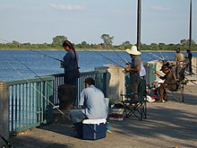
Canarsie Pier
Canarsie Pier in New York City is the smallest of the designated recreation areas within the Gateway National Recreation Areas and is located on the northwest shore of Jamaica Bay . It essentially consists of the 600- foot (180-meter) long pier, which has a catering service and is primarily used for fishing for flounder and blue fish.
Location and description
The pier in the New York borough of Brooklyn is a jetty built into the bay in the extension of Rockaway Parkway . Upstream about 600 meters is the march -Insel Canarsie Pol . Landside access is given to the pier with a large roundabout, which distributes car traffic to the Belt Parkway . The three-part entrance to the pier is designed with a wide gate above which the slightly curved lettering 'Canarsie Pier' and maritime symbols are attached. The middle opening, the width of two lanes, takes up more than twice the width of the two footpaths, which are arranged laterally and lead to the circumferential pedestrian area that surrounds the entire area of the pier.
The middle area is intended for parking around 250 cars ; towards the water, an approximately 15-meter-wide strip is designed as a footpath with seating and play facilities.
history
Canarsie goes back to a Dutch settlement. The settlers were the first Europeans to settle in this Long Islands region and to dispute the land against the local Lenni Lenape . In contemporary reports describing this settlement area, Canarsie is always mentioned . The oldest such document dates back to 1747.
From October 21, 1865, the steam-powered Brooklyn and Rockaway Beach Railroad offered a railway connection to the beach at Canarsie, because a ferry service to Rockaway on Long Island had been set up here and this place slowly developed into a popular leisure and vacation area . The ferry service to Rockaway (1866-1905) was unprofitable after the construction of the Rockaway Line (today Line A ) in the 1890s and therefore discontinued. From May 31, 1906, with the opening of the electrified Canarsie Railroad, another connection - (today Line L ) - was added to directly to the Canarsie Pier, which existed until 1940. It was operated by the Brooklyn-Manhattan Transit Corporation (BMT) subway company . Another ferry service to Barren Island closed in the 1930s.
At the beginning of the 20th century there were almost 20 hotels and many other entertainment and dining establishments. Many locals made a living from fishing and oyster fishing during this period. Because of the increasing discharge of untreated wastewater due to settlement densification, there were outbreaks of typhus in 1904 and 1915, which was transmitted to humans from shellfish. This led to the decline of this trade. Canarsie's reputation was ruined and the region began to decline. Canarsie received a final fatal blow during the Great Depression when much of the entertainment district burned down on January 29, 1934. A few years later, the six-lane Belt Parkway was built along the coast . With the merger of the New York subway companies in 1940, the route was shortened by two and a half kilometers or four stations to Rockaway Parkway for reasons of profitability .
By the 1970s, the neighborhood was transformed into a residential area primarily for Italians, Jews and Puerto Ricans. In 1973 the Canarsie Pier was declared a recreational area and placed under protection.
At the end of October 2012, Hurricane Sandy devastated the pier. It was rebuilt in six months and opened to the public on Memorial Day 2013.
Individual evidence
- ↑ a b From resort nights to white flight: a brief history of Canarsie , The weekly hub , May 3, 2012
- ↑ ogrforum
- ^ A b Frederick R. Black: Jamaica Bay: A History. Gateway National Recreation Area New York, New Jersey. Washington, DC, 1981, p. 66
- ↑ a b Weaving the Broadway Junction tapestry , The weekly hub , August 6, 2012
- ↑ Canarsie landing on roots web
- ^ Map of Canarsie at this time
- ↑ see also Jon Rieder: Canarsie: the Jews and Italians of Brooklyn against liberalism. , Harvard University Press 1985
- ↑ Canarsie Pier on New York Harbor Parks
- ↑ Canarsie Pier Re-Opens For Recreation , May 20, 2013
Web links
Coordinates: 40 ° 37 ′ 43 " N , 73 ° 53 ′ 2" W.


