Sandy Hook (peninsula)
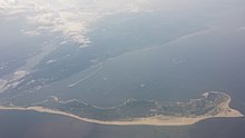
Sandy Hook is a barrier peninsula in Middletown , New Jersey . It is about 9.7 km long and between 100 meters and 1.6 km wide. It is located off the south end of New York Bay . Most of the island is owned and administered by the National Park Service .
description
Geologically, Sandy Hook is a barrier island on the coast of New Jersey, separated from the mainland by the estuary of the Shrewsbury River . On the west side of the island is the sheltered Sandy Hook Bay . This was a popular anchorage for ships en route to New York Harbor.
On paper, Sandy Hook belongs to Middletown, but there is no land connection between the districts, because where Sandy Hook borders the mainland, the place Highlands can be found . In addition, Sandy Hook's political affiliation is irrelevant, as the island is administered by the National Park Service, a federal agency.
There are several public beaches on the east side of the island: North Beach, Gunnison Beach, and South Beach. In the southern part there are more beaches, fishing areas and a restaurant. The beaches of South Beach are among the most beautiful in New Jersey and are very popular with residents of the nearby metropolis of New York . In the summer, ferries take bathers across the bay. Gunnison Beach is one of the largest “clothing-optional” beaches on the American east coast with a rapidly increasing number of visitors. Gunnison Beach was previously used by soldiers as a bathing beach - in military bathing trunks .
The beaches in the east are provided with the appropriate infrastructure - parking spaces, lifeguards, changing rooms - while the wide sand dunes on the west bank are practically devoid of infrastructure. Cyclists, kite surfers and people with their dogs have fun here .
There is no accommodation on Sandy Hook, but some hotel complexes can be found in the southern Highlands .
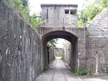
At the northern end of the peninsula is Fort Hancock , a disused Fort of the US Army . The Sandy Hook military test site was established shortly after the American Civil War and used for material testing and artillery fire. In 1919 the tests were moved to Aberdeen because the cannons now had too great a range to be tested here. After that, a Nike missile station was located here. Several of the old defenses are open to public tours, but access is partially forbidden because the structures are in too bad a condition. The island's military installations were retired in 1972.
The Sandy Hook Lighthouse is located about two and a half kilometers south of the northern tip of the peninsula, within the Fort Hancock area , and is the oldest active lighthouse in the United States. There is also a United States Coast Guard station north of the fort . It is one of the oldest life-saving stations in the United States and was built in 1848. It was rebuilt or postponed several times because the country was changing or because the War Department, to which the country belonged, so wanted.
traffic
There is only one road that goes from Highlands to Sandy Hook. There are also some popular routes for cyclists. In summer the peninsula can be reached by ferry from Manhattan .
Individual evidence
- ↑ Beth Greenfield: Sandy Hook, So Close to Manhattan, So Far Away in Spirit. , New York Times . August 5, 2005. Retrieved August 21, 2007. “Sometimes getting to the beach takes so much energy that it hardly seems worth the trip. Not so when the goal is Sandy Hook, a seven-mile stretch of paradise that's accessible from Manhattan with a ferry ride of about 30 minutes. "
- ↑ a b Rounds, Kate. "The Shore Next Door" Palisade magazine; Summer 2010; Pages 38-39
- ↑ Sea Streak . Sea streak. Retrieved December 17, 2012.
- ↑ Guy Trebay: All Undressed and So Many Places to Go , New York Times. September 2, 2001. Retrieved December 14, 2014. "Crowds are also increasing these final summer days at Blacks Beach near San Diego , at Mazo Beach on the lower Wisconsin River and at Gunnison Beach in Sandy Hook, New Jersey, a dress optional sand strip run by the National Park Service that was recently deemed by the Clean Beaches Council, an environmental group, one of the top 10 beaches in the United States. "
- ↑ Flam, Faye : "Clothing optional may not be way of historical human" . The Philadelphia Inquirer . July 17, 2006. Retrieved December 14, 2014: "" Sandy Hook boasts the biggest nude beach along the Atlantic. The clothing-optional part is called Gunnison Beach and there's even a picture showing people of varying shapes and sizes frolicking in their birthday suits.
- ^ Margot Adler : Nude Beach Thrives In New Jersey , NPR . July 21, 2008. Retrieved July 25, 2008. “It officially opened as a clothing-optional beach not long after it was decommissioned as a military base in 1972. When it was a military base, the soldiers - all men - would skinny dip, according to Dale Distasio, president of Friends of Gunnison. "
- ^ Sandy Hook Station, New Jersey . In: US Coast Guard History Program . United States Coast. Retrieved December 14, 2014.
- ↑ Sea Streak . Sea streak. Retrieved December 17, 2012.
- ↑ American Princess Cruises . Newyorkbeachferry.com. Retrieved December 17, 2012.
Web links
- Sandy Hook Visitor Information
- National Park Service Gateway National Recreation Area
- Nike Missile Site NY-56
Coordinates: 40 ° 27 '10.4 " N , 73 ° 59' 42.9" W.


