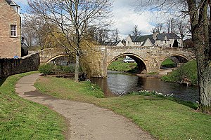
Canongate Bridge
Coordinates: 55 ° 28 ′ 41 ″ N , 2 ° 33 ′ 4 ″ W.
| Canongate Bridge | ||
|---|---|---|
| The Canongate Bridge | ||
| use | footbridge | |
| Convicted | sidewalk | |
| Subjugated | Jed Water | |
| place | Jedburgh | |
| construction | Stone arch bridge | |
| Number of openings | 3 | |
| completion | 16th Century | |
| location | ||
|
|
||
The Canongate Bridge is a former road bridge in the Scottish town of Jedburgh in the Council Area Scottish Borders . The building, which is now only used by pedestrians, was included in the Scottish monument lists in 1971 in the highest monument category A.
description
Canongate Bridge is a 16th century stone arch bridge that crosses Jed Water in central Jedburgh. The masonry viaduct made of cream-colored sandstone spans the river with three segmental arches , one of which runs over land. The roadway is up to three meters wide. From the time when the Canongate Bridge was still used as a road bridge, pedestrian bays have been preserved above the pointed icebreakers . Today the bridge is closed to motorized traffic. Once there was a gatehouse in its center, which has since been demolished.
Individual evidence
- ↑ a b c Listed Building - Entry . In: Historic Scotland .
- ↑ Entry on Canongate Bridge in Canmore, the database of Historic Environment Scotland (English)
- ^ Information from the Council of the Scottish Borders
Web links
- Entry on Canongate Bridge in Canmore, Historic Environment Scotland database

