
Cap de Barbaria
| Cap de Barbaria | ||
 Lighthouse at the Cap de Barbaria |
||
| Geographical location | ||
|
||
| Coordinates | 38 ° 39 '19 " N , 1 ° 23' 42" E | |
| Waters 1 | Mediterranean Sea | |
| Remarks | ||
| Location in Formentera | ||

The Cap de Barbaria is the southwestern cape of Formentera , the southernmost Balearic island .
The cape is located on a rocky, over 100 meter high coast in an unpopulated nature reserve with only sparse vegetation. There are a number of archaeological sites, some smaller caves, a lighthouse and a watchtower ("Torre") from the 18th century.
Archaeological sites
Of the 33 archaeological sites at Cap de Barbaria, 21 belong to prehistory and early history (1800–1000 BC), and eight from the Punians and Romans to the medieval Islamic period. Four other finds cannot be dated. The locations of Cap de Barbaria I ⊙ , Cap de Barbaria II ⊙ and Cap de Barbaria III ⊙ are fenced and easy to reach from the road (PMV-820.1).
Other archaeological sites on Formentera are the Cova des Fum and the megalithic complex Ca na Costa .
photos
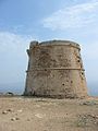
Watchtower from the 2nd half of the 18th century on the Cap

View of the Cap de Barbaria


Web links
Individual evidence
- ↑ Cap de Barbaria , L'Enciclopèdia d'Eivissa i Formentera, accessed on April 16, 2017 (Catalan)