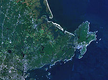
Cape Ann
Cape Ann on the Atlantic Ocean consists of the eastern headland of Essex County ( Massachusetts ) and is located about 30 km northeast of Boston . The northernmost tip of Cape Ann is formed in the extreme north by Halibut Point . Cape Ann includes Ipswich Bay and is cut in the north at Annisquam Harbor and in the south at Gloucester Harbor . These two ports are connected by the tidal 6.4 km long navigable Annisquam River . The cape forms the northern end of Massachusetts Bay , which extends south to Cape Cod . On the Cape are the cities of Gloucester , Essex, Manchester-by-the-Sea and Rockport.
The first settlers came to Cape Ann in 1623 on the initiative of Rev. John White , who had the first fishing settlement established by the Dorchester Company near present-day Gloucester. They named the rocky, picturesque foothills after Anna of Denmark , the wife of the English King James I. (The naming was analogous to Cape Cod , which was also known as Cape James !)
One of the worst shipping accidents in the region to date occurred on November 26, 1898, when the American liner Portland sank off Cape Ann in a severe storm that struck the New England coast and claimed more than 450 lives . All 192 people on board were killed. The storm is therefore called The Portland Gale (roughly "The Portland Storm").
Cape Ann is known for its quaint fishing villages and artist colonies . The most typical and famous places on Cape Ann are Gloucester and Rockport.
literature
- Norman's Woe , a reef on the east coast of the Cape, has been the scene of numerous shipping disasters . It therefore forms the setting for Henry Wadsworth Longfellow's poem The Wreck of the Hesperus .
- The horror author HP Lovecraft makes the area around Cape Ann the setting for numerous stories. So he settles numerous fictional places in the area around the cape, u. a. Kingsport, Innsmouth and Arkham .
Web links
- ArtsGloucester (English)
- Society for Promotion of Arts (English)
- The Sargent House Museum (English)
Coordinates: 42 ° 38 ′ N , 70 ° 38 ′ W

