Cartavio (Coaña)
| Coaña municipality: Parroquia Cartavio | ||
|---|---|---|
| coat of arms | Map of Spain | |

|
|
|
| Basic data | ||
| Autonomous Community : |
|
|
| Comarca : | Eo-Navia | |
| Coordinates | 43 ° 19 ′ N , 6 ° 28 ′ W | |
| Height : | 645 msnm | |
| Area : | 9.7 km² | |
| Residents : | 572 (January 1, 2011) INE | |
| Population density : | 58.97 inhabitants / km² | |
| Postal code : | 33719 | |
| Area code: | 33018010000 | |
| Nearest airport : | Asturias airport 72.6 km | |
| administration | ||
| Address of the municipal administration: | Carretera de Jarrio-coaña, s / n, 33795 COAÑA | |
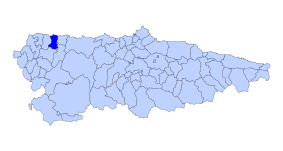
| Location of the municipality | ||

|
||
Cartavio is one of eight parroquias in the municipality of Coaña in the autonomous community of Asturias in Spain .
geography
Cartavio is a Parroquia with 572 inhabitants (2011) and an area of 9.7 km². It is at 67 m. Cartavio is 8.3 km from Coaña , the capital of the municipality of the same name. The place is on the Way of St. James , the Camino de la Costa .
Waters in the Parroquia
Cartavio is located between the Rio Miudes and Rio del Pinto rivers .
economy
Agriculture has shaped the region since time immemorial.
climate
Pleasantly mild summers with mild, rarely severe winters. In the high areas, winters can be quite severe.
Regular events
- September 12th, Fiesta de Nuestra Señora del Rosario de Cartavio
Villages and hamlets in the Parroquia
| Surname | in the Asturian | Residents 2011 | Coordinates |
|---|---|---|---|
| Cartavio | 216 | 43 ° 32 ′ 41 " N , 6 ° 47 ′ 16" W. | |
| El Esteler | L'Esteler | 34 | 43 ° 32 ′ 36 " N , 6 ° 47 ′ 13" W. |
| Jonte | Xonte | 31 | |
| Loza | Lloza | 190 | 43 ° 33 ′ 30 ″ N , 6 ° 46 ′ 19 ″ W. |
| Lugarnuevo | Llugarnovo | 12 | |
| San Cristobal | 19th | 43 ° 33 ′ 2 " N , 6 ° 47 ′ 56" W. | |
| Silvarronda | 42 | 43 ° 32 ′ 19 ″ N , 6 ° 47 ′ 2 ″ W. | |
| Villalocay | Villallocái | 28 | 43 ° 33 ′ 16 ″ N , 6 ° 46 ′ 8 ″ W. |
