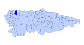
Llebredo (Parroquia)
| Municipality of Boal: Parroquia Llebredo | ||
|---|---|---|
| coat of arms | Map of Spain | |
 Help on coat of arms |
|
|
| Basic data | ||
| Autonomous Community : |
|
|
| Comarca : | Eo-Navia | |
| Coordinates | 43 ° 29 ′ N , 6 ° 49 ′ W | |
| Height : | 353 msnm | |
| Area : | 13.86 km² | |
| Residents : | 53 (January 1, 2011) INE | |
| Population density : | 3.82 inhabitants / km² | |
| Postal code : | 33719 | |
| Area code: | 33023040000 | |
| Nearest airport : | Asturias airport 84.5 km | |
| administration | ||
| Address of the municipal administration: | Carretera de Jarrio-coaña, s / n, 33795 COAÑA | |
| Location of the municipality | ||

|
||
Llebredo is one of eight parroquias in the municipality of El Franco . It also extends to the municipalities of Coaña and Boal of the autonomous region of Asturias in Spain .
geography
Llebredo is a Parroquia with 53 inhabitants in (El Franco), 14 inhabitants in (Boal) and 25 inhabitants in (Coaña) (2011) and an area of 13.86 km². It is 363 m above sea level . Llebredo is eight kilometers from the capital of the municipality of El Franco .
economy
Agriculture has shaped the region since time immemorial. In recent times, the dairy industry and with it the corresponding "industry" such as cheese and other dairy products have spread widely.
climate
Pleasantly mild summers with mild, rarely severe winters. In the high areas, winters can be quite severe.
Villages and hamlets in the Parroquia
- Brañamayor
- Coba
- Llebredo
Worth seeing
- Cueva (cave) de la Andina
swell
- Population figures see INE: Boal , Coaña and El Franco
- Postcodes on Codigo-Postal.info
- Height information Google Earth
