
Carversville
| Carversville | |||
|---|---|---|---|
.jpg) Church in Carversville |
|||
| Location in Pennsylvania | |||
|
|||
| Basic data | |||
| State : | United States | ||
| State : | Pennsylvania | ||
| County : | Bucks County | ||
| Coordinates : | 40 ° 23 ′ N , 75 ° 4 ′ W | ||
| Time zone : | Eastern ( UTC − 5 / −4 ) | ||
| Residents : | 100 (as of 2010) | ||
| Height : | 69 m | ||
| Postal code : | 18913 | ||
| Area code : | +1 215 and 267 | ||
| GNIS ID : | 1203228 | ||
| Website : | www.carversville.com | ||

Carversville is a village in Solebury Township , Bucks County , Pennsylvania . Carversville is located at the intersection of Carversville Road, Aquetong Road, and Fleecy Dale Road and is an unincorporated village. The historic part of the village center was added to the National Register of Historic Places in 1979.
history
In what is now Carversville, Lenni Lenape Indians originally settled and called the area Aquetong the "many springs". Over 300 years ago, William Penn gave the land to James Harrison and Joseph Pike. James Harrison sold his 500 acre to Randall Blackshaw who divided it into 100 acre pieces.
The original name of the village was "Indian Village". Later the village was also called Mill Town, then Milton and from 1833 Carversville. Carver was the surname of the postmaster from that time.
In 1838 the first Christian church was founded and a Presbyterian church was added in 1872.
Today the local hotel "Carversville Inn" is an attraction for many travelers.

Carversville Inn
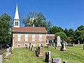
church

Shop in the village


Individual evidence
- ^ State Park Office: National Register Historic Districts & Homes. Retrieved July 10, 2017 .
- ↑ www.carversville.com. (No longer available online.) Archived from the original on May 12, 2016 ; Retrieved July 10, 2017 . Info: The archive link was inserted automatically and has not yet been checked. Please check the original and archive link according to the instructions and then remove this notice.