
Cathcart (South Africa)
| Cathcart | |||
|---|---|---|---|
|
|||
| Coordinates | 32 ° 18 ′ S , 27 ° 9 ′ E | ||
| Basic data | |||
| Country | South Africa | ||
| Eastern Cape | |||
| District | Amathole | ||
| ISO 3166-2 | ZA-EC | ||
| local community | Amahlathi | ||
| Residents | 2310 (2011) | ||
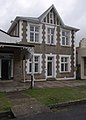
 Historic building of the city administration
|
|||

Cathcart is a town in the Amahlathi municipality , Amathole District , Eastern Cape Province in the Republic of South Africa. In 2011 the city had 2,310 inhabitants. The distance to the Indian Ocean and East London is 145 kilometers by road.
Geographical location, traffic
The town of Cathcart is located at the intersection of two streets and is one of the most easterly points in the Amathole region. It lies east of the major national road N6 between Queenstown and King William's Town . A road crosses in a south-west-north-east direction, coming from the hinterland of the Amathole Mountains in the direction of Swart-Kweirivier . Its original meaning arose from the military considerations of the white immigrants in the course of the 19th century, especially through the effects of the border wars .
A railway line connects Cathcart with Queenstown, Aliwal North and Middelburg in the north and Stutterheim and East London in the south.
The city is traversed by a network of streets laid out at right angles.
Population, employment situation
The population consists mainly of members of the Xhosa and whites. Cathcart is a small center in a former farm area in South Africa. The decline in agriculture led to job losses and emigration. There are only a few businesses and dealers. Other employers are the small town council, the bank and some small offices.
An attempt is being made to attract South African tourists to the region through gentle tourism with equestrian sports, mountain biking , wildlife observation, fishing and hiking.
history
Cathcart's name goes back to a person in South African colonial history. Sir George Cathcart was High Commissioner of the Cape Colony from 1852 to 1854 . The settlement, which was founded as a front post office, has borne his name since 1876.
Attractions
- 19th century buildings, individual town houses and the Cathcart public library
- Saint Alban Church
- CM van Coller Museum
- Memorial to those who fell in World War I on Hauptstrasse
Town house on the main street

Memorial to those who fell in the First World War

Historic leaded glazing in the city administration

City library building


Surroundings
To the west and south-west of Cathcart is a mountainous country with grassy, almost flat sections, which slowly ascends to the highest peaks of the Amathole Mountains. In the grasslands there are isolated farms where livestock is raised.
Directly west of the city, the Windvoelberg (German: "Windvogelberg") massif rises with steep slopes, up to 1,629 meters. As a result, the city is in a relatively protected location because of the main wind direction.
To the south, not far from the N6 national road, is the museum village and former train station Old Thomas River Village .
geology
The relief of the region around Cathcart is formed by sediments of the Beaufort group . It is mostly sandstones that are also visible in the cityscape.
Web links
- Official website of the municipality (English)
Individual evidence
- ↑ 2011 census , accessed November 22, 2013