
Cerro Pan de Azúcar
| Cerro Pan de Azúcar | ||
|---|---|---|
 Cerro Pan de Azúcar |
||
| height | 389 m | |
| location | Pan de Azúcar , Maldonado Department , Uruguay | |
| Coordinates | 34 ° 48 ′ 33 " S , 55 ° 15 ′ 31" W | |
|
||
| particularities | third highest point in Uruguay | |

The Cerro Pan de Azúcar (German: Sugar Loaf ) is a mountain in Uruguay .
With a summit height of 389 m, it is the third highest point in Uruguay. At the top of the conical Cerro Pan de Azúcar is a 32-meter-high cross that can be climbed via a spiral staircase located inside. The mountain is located in the department of Maldonado in the city of Pan de Azucar isolated from the not far away at Piriápolis almost to the Río de la Plata reaching Sierra de las Animas .


Summit cross
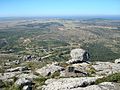
View from the summit to the southeast


Web links
Commons : Cerro Pan de Azúcar - Collection of images, videos and audio files
- Cerro Pan de Azúcar on maldonado.gub.uy
- www.cerropandeazucar.com , accessed September 30, 2012
Individual evidence
- ↑ GEOGRAFÍA Cuchilla Grande - Cerro Pan de Azúcar . In: Enciclopedia Geografica del Uruguay . Acerca de Montevideo COMM , accessed May 17, 2010 (Spanish).
- ↑ Prostar Sailing Directions 2004 East Coast of South America Enroute , National Geospatial-Intelligence Agency, p 114
- ↑ Thomas Binder: "South America 2 - Argentina - Chile - Uruguay - Paraguay", DuMont Buchverlag Cologne, 1978, p. 206.
- ^ Structure and surface forms in Die La Plata-Länder by Herbert Wilhelmy , Wilhelm Rohmeder , 1963, p. 20.