
Piriápolis
| Piriápolis | ||
|---|---|---|
|
Coordinates: 34 ° 52 ′ S , 55 ° 16 ′ W Piriápolis on the map of Uruguay
|
||
| Basic data | ||
| Country | Uruguay | |
| Department | Maldonado | |
| City foundation | 1893 | |
| Residents | 8830 (2011) | |
| Detailed data | ||
| height | 0 m | |
| Waters | Río de la Plata | |
| Post Code | 20200 | |
| prefix | (+598) 43 | |
| Time zone | UTC −3 | |
| City Presidency | Mario Invernizzi | |
 |
||
 |
||
 |
||

Piriápolis is a city in Uruguay in the Maldonado department .
geography
Location and landscape
It is located about 35 km from the city of Maldonado on the banks of the Río de la Plata . The landscape of the hinterland is determined by the Sierra de las Ánimas located there . The Cerro Pan de Azúcar is around six kilometers away .
Natural resources
At Piriápolis there are deposits of gray and red granite .
history
Piriápolis was founded in 1893 by Francisco Piria . The first building was a castle, built in 1897, after a model on the Italian Riviera. This was followed by structures such as the port of Piriápolis, the Rambla De Los Argentinos, a railway line, the church, the Hotel Piriápolis and the Argentino Hotel. On June 21, 1960, Ley 12,736 was classified as a Ciudad (city) as part of the statutory regulation .
Infrastructure
education
Piriápolis has a secondary school ( Liceo ) with the Liceo de Piriápolis "José Luis Invernizzi" founded on March 17, 1958 .
Leisure and Tourism
Piriápolis is equipped with an infrastructure designed for tourism and is one of the most important seaside resorts in the country. The city, which has beaches on the coast, has more than 50 hotels, a marina, a golf course and a zoo, in which the animal species living in Uruguay are represented. The Argentino Hotel is one of the most distinctive buildings in Piriápolis .
traffic
In terms of transport infrastructure, the city is connected via the road network to the Ruta Interbalnearia , which runs a few kilometers to the north, and is thus connected to the centers of Montevideo and Maldonado / Punta del Este to the west and east , with which there is a regular bus service several times a day.
Residents
The 2011 census counted 8,830 inhabitants in Piriápolis, 4,238 men and 4,592 women.
| year | Residents |
|---|---|
| 1963 | 4,549 |
| 1975 | 5,240 |
| 1985 | 5,878 |
| 1996 | 7,570 |
| 2004 | 7,899 |
| 2011 | 8,830 |
Source: Instituto Nacional de Estadística de Uruguay
City administration
Mayor ( Alcalde ) of Piriápolis is Mario Invernizzi .

Argentino Hotel

view on the city
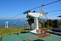
Chairlift to Cerro San Antonio

Piriapolis, view from Cerro San Antonio


sons and daughters of the town
- Julio Balerio (1958-2013), football player and coach
- Facundo Cabrera (* 1991), football player
- Ladislao Mazurkiewicz (1945–2013), football player and coach
- Federico Ramos (* 1991), football player
Web links
- City map of Piriápolis (PDF; 245 kB)
- Official website of the Department of Maldonado Administration
- Information about Piriápolis (Spanish) (German)
Individual evidence
- ^ Códigos Postales del Interior , accessed February 26, 2012
- ^ Prof. Ulises Rubens Grub : Atlas geografico de la República Oriental del Uruguay, Montevideo 1980, p. 35
- ↑ Liceos del Uruguay (Spanish) (PDF; 7.3 MB), accessed on February 29, 2012
- ↑ Argentina Handbook by René Junghans, Kiel 1990, p. 266
- ↑ Statistical data ( memento of September 7, 2012 in the Internet Archive ) of the Instituto Nacional de Estadística de Uruguay , accessed on September 27, 2012
- ↑ Statistical data of the Instituto Nacional de Estadística de Uruguay 1963–1996 (DOC; 148 kB)
- ↑ Statistical data from the Instituto Nacional de Estadística de Uruguay 2004 as an xls file ( Memento from March 9, 2013 in the Internet Archive )
- ↑ "MUNICIPIOS DE URUGUAY" on the website of the Uruguayan Congress of Directors ( Memento of March 8, 2012 in the Internet Archive )