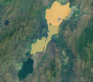
Chamo lake
| Chamo lake | ||
|---|---|---|

|
||
| The Abajasee above and the Chamoee below | ||
| Geographical location | in the south of Ethiopia |
|
| Tributaries | Temporary overflow from the Abajasee | |
| Drain | temporarily towards Sagan | |
| Location close to the shore | Arba Minch | |
| Data | ||
| Coordinates | 5 ° 50 ′ N , 37 ° 33 ′ E | |
|
|
||
| Altitude above sea level | 1110 m | |
| surface | 317 km² | |
| length | 32 km | |
| width | 13 km | |
| Maximum depth | 14 m | |
| Catchment area | 2220 km² | |
The Chamo ( Amharic ጫሞ ሐይቅ č'amo Hayq, German and Shamosee or Tschamosee written) is a lake in the southern Ethiopian ditch near the town of Arba Minch .
description
The lake is located south of Lake Abaya and east of the Guge Mountains . The northern end is in the Nechisar National Park and is separated from Lake Abaya by the “Bridge of God”, an isthmus .
It is about 32 kilometers long and 13 kilometers wide. At its deepest point it is 14 meters deep and the area of the lake is approximately 317 km². The lake is about 1110 meters above sea level. NN. The area around the lake is shaped by savannah and is known for its rich wildlife.
Oscar Neumann explored the area around 1901 and found a dry canal that connects Lake Chamo with the Sagan River, which led him to conclude that in years with heavy rains the lake drains into the Sagan. In some years the Chamo lake is fed by the overflow of the Abajasee.
Individual evidence
- ↑ Robert Mepham, RH Hughes, and JS Hughes, A directory of African wetlands Page 163
- ↑ Water Resources and Irrigation Development in Ethiopia - IWMI ( Memento of July 18, 2011 in the Internet Archive ) (PDF; 701 kB)
