Chimalhuacan
| Chimalhuacan | ||
|---|---|---|
|
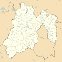
Coordinates: 19 ° 26 ′ N , 98 ° 57 ′ W Chimalhuacán on the map of Mexico
|
||
| Basic data | ||
| Country | Mexico | |
| State | México | |
| Municipio | Chimalhuacan | |
| Residents | 612,383 (2010) | |
| City insignia | ||
| Detailed data | ||
| height | 2243 m | |

Chimalhuacán [ tʃimalwaˈkan ] ( Nahuatl place of shields ) is a city in the state of México in Mexico . It lies outside the northeast border of the federal district ( Distrito Federal ) and is part of the Zona Metropolitana del Valle de México . With more than 600,000 inhabitants, the city is the capital of the Municipio Chimalhuacán .
Chimalhuacán was founded in 1259 by the three chiefs ( tlatoani plural: tlatoque) Huauxomatl , Chalchiutlatonac and Tlatzcantecuhtli . Like their people, these chiefs came from the north and spoke Chichimeca and Nahuatl, but in time, Nahuatl became the dominant language. Chimalhuacán was subjugated by Texcoco and from 1431 belonged to the Aztec Triple Alliance .
After Hernán Cortés had conquered the country, the population fled. Therefore, the city was re-established by the Spanish in 1563. The Dominicans built a church and a monastery during this period.
Web links
- Municipio de Chimalhuacán Official Website
- Enciclopedia de los Municipios y Delegaciones de México: Chimalhuacán (Spanish)

