Chortiatis
| Chortiatis (Χορτιάτης) | ||
|---|---|---|
|
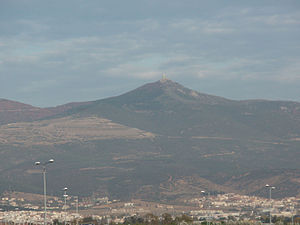
The Chortiatis seen from Thessaloniki Airport. |
||
| height | 1201 m | |
| location |
Thessaloniki and Chalkidiki Central Macedonia , Greece |
|
| Mountains | Chortiatis | |
| Coordinates | 40 ° 35 ′ 0 ″ N , 23 ° 7 ′ 0 ″ E | |
|
|
||
The Chortiatis ( modern Greek Χορτιάτης ( m. Sg. ); Ancient name : Kissos , ancient Greek Κίσσος ; English transcription Hortiatis ) is a maximum 1201 meter high Greek mountain range in the Central Macedonia region . Its main ridge extends from northwest to southeast. The north-western part extends with its foothills to the Thermaic Gulf : on these foothills the towns and communities of the metropolitan region of Thessaloniki as well as the city of Thessaloniki itself extend proportionally . The south-eastern part merges into the highlands of the Chalkidiki peninsula . On its western flank is the Anthemous valley, named after the river of the same name. The airport of Thessaloniki is located directly on the Thermaic Gulf . At its height, a few kilometers to the east, there is the main summit of the same name of the Chortiatis with a height of 1201 m.
The heights of the Chortiatis massif are forested. The forest bordering the metropolitan area of Thessaloniki is called Seich-Sou .
After the Chortiatis massif, a downwind and the community Pylea-Chortiatis , which surrounds the massif, is named.
The Chortiatis played a decisive role for the water supply of the city of Thessaloniki, especially in the Byzantine period. In the late Byzantine period (around 1300) the Chortaïtes monastery was located on the northern slopes of the Chortiatis. It supplied the city of Thessaloniki and the region east of it with water through an aqueduct , the remains of which have been partially preserved. In the early 15th century, a late 12th century basilica formed the core of a settlement, the Chortiatis Kastron. From the late 14th century, three cisterns in the area of the Vlatades Monastery collected water from the Chortiatis for the supply of the city of Thessaloniki.
Individual evidence
- ↑ Zahrnt, Michael: Olynth and the Chalkidians: Studies on the formation of states on the Chalkidik peninsula in the 5th and 4th centuries BC Chr. CH Beck, Munich 1971. ISBN 3-406-03097-1 . P. 28.
- ↑ a b Bakirtzis, Charalambos: The Urban Continuity and Size of Late Byzantine Thessalonike. In: Talbot, Alice Mary (Ed.): Symposium on Late Byzantine Thessaloniki. Dumbarton Oaks Papers, No. 57th Symposium on Late Byzantine Thessaloniki. Dumbarton Oaks Papers, No. 57. Dumbarton Oaks Research Library and Collections, Washington DC 2003. pp. 36-64. S. 60. ( PDF ( Memento of the original from February 14, 2014 in the Internet Archive ) Info: The archive link has been inserted automatically and has not yet been checked. Please check the original and archive link according to the instructions and then remove this notice. )
- ↑ a b c Bakirtzis, Charalambos: The Urban Continuity and Size of Late Byzantine Thessalonike. In: Talbot, Alice Mary (Ed.): Symposium on Late Byzantine Thessaloniki. Dumbarton Oaks Papers, No. 57th Symposium on Late Byzantine Thessaloniki. Dumbarton Oaks Papers, No. 57. Dumbarton Oaks Research Library and Collections, Washington DC 2003. pp. 36-64. P. 38. ( PDF ( Memento of the original from February 14, 2014 in the Internet Archive ) Info: The archive link has been inserted automatically and has not yet been checked. Please check the original and archive link according to the instructions and then remove this notice. )

