Cibla
| Cibla | ||
|---|---|---|
 Help on coat of arms |
|
|
| Basic data | ||
| State : |
|
|
| Landscape: | Latgale ( Latvian : Latgale ) | |
| Administrative district : | Ciblas novads | |
| Coordinates : | 56 ° 33 ' N , 27 ° 53' E | |
| Residents : | 216 | |
| Area : | ||
| Population density : | ||
| Height : | 118 m | |
| Website: | www.ciblasnovads.lv | |
| Post Code: | ||
| ISO code: | ||
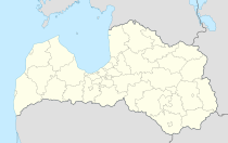
Cibla is a town in eastern Latvia on the border with Russia .
history
The first written mention of an estate was in 1739 as "Ewersmuyze" (Latvian: Eversmuiža ). The municipality of Eversmuiža was then renamed Cibla in 1925 after a nearby historic Latgale castle hill . In more recent times, the village around the former estate is also known as Cibla. There is a middle school, a Volkshaus, a Feldscher station and a Catholic church in the village.
Ciblas novads
Ciblas novads was formed in 2009 from the municipalities of Cibla, Blonti, Līdumnieki, Pušmucova and Zvirgzdene. The administrative center is in Blonti. Ciblas novads has an area of 509.4 km². The population was 3309 in 2010, but is on the decline due to a lack of jobs.
Novads Cibla maintains a town partnership with the Lower Saxony municipality of Bad Bodenteich .
literature
- Astrīda Iltnere (ed.): Latvijas Pagasti, Enciklopēdija. Preses Nams, Riga 2002, ISBN 9984-00-436-8 .
Web links
- Partnership Bad Bodenteich and Cibla (German, Latvian)
- Reģionālās attīstības un pašvaldību lietu ministrija ( MS Word ; 1.2 MB)

