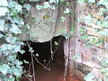
Claus-Stolln
The Claus-Stolln is an approximately two-kilometer-long water dissolving gallery in the hard coal area of the Döhlen basin in the area of the city of Freital in Saxony . It served the drainage of the coal village and Pesterwitz mine field , which originally belonged to the Claus heirs of Thümen.
history
The Claus-Stolln was excavated by the owners between 1727 and 1757 over a length of 1900 meters. In 1752 it reached the seam of the Kohlsdorf-Pesterwitz secondary hollow, which is drained with two wing words.
The cross-section of the tunnel is about one square meter, with an average height of two meters, it is about half a meter wide. A measurement in 1862 showed an average discharge of 250 liters per minute. The water diverted to Wiederitz has an intense red color due to the dissolved ocher .
After 1990 the mouth hole was rebuilt. The newly made keystone bears the year 1726 in addition to mallets and iron .
literature
- Eberhard Gürtler, Klaus Gürtler: The hard coal mining in the Döhlen Basin part 2 - shafts on the left of the Weißeritz , house of the home Freital, 1984
Individual evidence
- ↑ In Saxony, the spelling Stolln is used instead of Stollen. "Claus-Stolln" as a proper name is spelled correctly.
- ↑ Claus-Stolln ( page no longer available , search in web archives ) Info: The link was automatically marked as defective. Please check the link according to the instructions and then remove this notice. in the database MontE of the TU Freiberg
Coordinates: 51 ° 0 '59.6 " N , 13 ° 38' 42.9" E
