
Clearwater Memorial Causeway
Coordinates: 27 ° 58 ′ 18 " N , 82 ° 48 ′ 50" W.
| Clearwater Memorial Causeway | ||
|---|---|---|
.jpg) |
||
| use | Road traffic on |
|
| Crossing of | Atlantic Intracoastal Waterway | |
| place |
|
|
| Entertained by | State Highway Agency | |
| Building number | 1080460 | |
| overall length | 713.2 m (2340 feet) | |
| width | 34.3 m (112.5 feet) | |
| Longest span | 109.7 m (359.9 feet) | |
| height | 22 m (72.2 feet) above sea level | |
| vehicles per day | approx. 39,500 (2016) | |
| building-costs | about $ 45 million | |
| start of building | 2001 | |
| opening | August 2005 | |
| planner | HDR Engineering, Inc. | |
| location | ||
|
||

The Clearwater Memorial Causeway is a highway bridge in the US state of Florida in Pinellas County . It connects Clearwater with the Clearwater Beach district.
history
First a wooden bridge was created in 1915. The road bridge that followed in the 1920s was a two-lane drawbridge that rose only a few meters above sea level. In 1963 a new bridge was built, which was slightly higher than the old bridge. This was built according to the design of the Madeira Beach Causeway . In the same year, the bridge from the 1920s was partially demolished and converted into a jetty. Finally, today's bridge, which opened in 2005, was built at a sufficient height of approx. 22.5 meters.
The bascule bridge from the 1960s met the requirements for decades, but from the year 2000 onwards there were signs of overload due to the high volume of vehicles. Another point for the new construction was that the lane of the bridge was too deep for shipping and therefore not all ships could use the Atlantic Intracoastal Waterway. Work on today's bridge began in 2001; Much controversy arose during construction. In 2004, some of the pillars broke outward so far that the bridge was unsafe. A year later, after replacing the damaged pillar, the bridge was opened.
Information and data
The bridge has a total length of 713.2 meters. The width is 22 meters between the two curbs and 34.3 meters between the two edges. The height from the roadway to sea level is 22 meters. The estimated cost was approximately $ 45 million. Florida State Road 60 leads over the bridge .
gallery
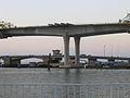
Pillar of the bridge (the 1963 bridge can be seen in the background)

Bridge lanes


Web links
Individual evidence
- ^ Clearwater Memorial Causeway. Retrieved April 1, 2020 .
- ↑ ASBI - ASBI - Projects. Retrieved April 1, 2020 .
- ↑ BridgeReports.com | SR-60 over CLEARWATER HARBOR, Pinellas County, Florida. Retrieved April 1, 2020 .