Coal River (Liard River)
| Coal River | ||
|
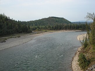
View from BC Highway 97 over the Coal River near Cranberry Rapids |
||
| Data | ||
| location | British Columbia , Yukon ( Canada ) | |
| River system | Mackenzie River | |
| Drain over | Liard River → Mackenzie River → Arctic Ocean | |
| Headwaters | south of the Selwyn Mountains 61 ° 32 ′ 38 " N , 127 ° 40 ′ 57" W |
|
| Source height | approx. 1800 m | |
| muzzle | at Coal River in the Liard River coordinates: 59 ° 39 ′ 12 " N , 126 ° 57 ′ 24" W 59 ° 39 ′ 12 " N , 126 ° 57 ′ 24" W |
|
| Mouth height | approx. 470 m | |
| Height difference | approx. 1330 m | |
| Bottom slope | approx. 4.9 ‰ | |
| length | approx. 270 km | |
| Catchment area | approx. 9230 km² | |
| Discharge A Eo : 9190 km² Location: 8 km above the mouth |
MQ 1967/1994 Mq 1967/1994 |
95 m³ / s 10.3 l / (s km²) |
| Left tributaries | Rock river | |
| Right tributaries | West Coal River | |
| Communities | Coal River | |
The Coal River is an approximately 270 km long left tributary of the Liard River in the southeast of the Yukon Territory and adjacent British Columbia in Canada .
It rises in the south of the Selwyn Mountains in the Yukon. It flows in a south-south-westerly direction through the mountains. The West Coal River meets the river from the right. The river flows around the 16 km² Coal River Springs Territorial Park ( ⊙ ) southwest of Mount Gilliland and turns to the east. At the confluence of the Rock River , the Coal River turns south again, crossing the border into British Columbia. After another 65 km within British Columbia, it finally reaches the Liard River at the village of Coal River. The British Columbia Highway 97 ( Alaska Highway ) crosses the Coal River here.
The Coal River drains an area of about 9230 km². Its mean discharge is 95 m³ / s. Between May and July, the Coal River carries the largest amounts of water.
The Coal River is a popular white water body for canoeists . The river is considered a very demanding canoe river with its rapids of difficulty III-IV. 10 − day tours starting at Lucky Lake on a small tributary in the upper reaches lead down the river to its mouth.
Web links
- Coal River . In: BC Geographical Names (English)
- Geographical Names of Canada: Coal River
- Coal River Springs Territorial Park
Individual evidence
- ↑ Coal River at the gauge at the mouth - hydrographic data from R-ArcticNET
- ^ A b c Government of Canada: Historical Hydrometric Data Search Results: Station 10BC001
