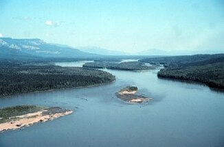
Liard River
The Liard River is a 1,115-kilometer-long left tributary of the Mackenzie River in the Yukon Territory , the Northwest Territories, and the Province of British Columbia .
The river has its source in the Pelly Mountains in southeastern Yukon. It flows mainly in an easterly direction. He forms the northern limit of the Rocky Mountains . Between the mouths of the Trout River and Toad River, the Liard River flows through the so-called "Grand Canyon of the Liard", a steep-walled gorge. The Liard River finally flows into the Mackenzie River at Fort Simpson , located in the Northwest Territories. The Liard River drains an area of approximately 277,100 km² and flows through the Liard River Valley .
In British Columbia there are several Provincial Parks on the Liard River , including the Smith River Falls - Fort Halkett Provincial Park with the Smith River waterfall just before it flows into the Liard River, the Liard River Hot Springs Provincial Park with its hot springs and the Liard River West Corridor Provincial Park .
history
The name of the river is derived from the French name "liard" for the Canadian black poplars ( Populus deltoides ) that grow on the banks of the river.
Tributaries
- Beaver River
- Trout River
- Toad River
- South Nahanni River
- Muskeg River
- Petitot River
- Kotaneelee River
- Fort Nelson River
- Kechika River
- Hyland River
- Dease River
- Frances River
Web links
- Liard River . In: BC Geographical Names (English)
- Liard River ( English, French ) In: The Canadian Encyclopedia .
- Geographical Names of Canada: Liard River
Individual evidence
- ↑ a b The Atlas of Canada - Rivers ( Memento from January 22, 2013 in the Internet Archive ) (English)
- ↑ Liard River at the gauge above the Kechika River - hydrographic data from R-ArcticNET
- ↑ Liard River at the gauge above Beaver River - hydrographic data from R-ArcticNET
- ^ Liard River at Fort Liard gauge - hydrographic data from R-ArcticNET
- ↑ Liard River at the gauge near the mouth - hydrographic data from R-ArcticNET
- ^ Grand Canyon of the Liard . In: BC Geographical Names (English)
