Watson Lake
| Watson Lake | ||
|---|---|---|
 Watson Lake, Yukon |
||
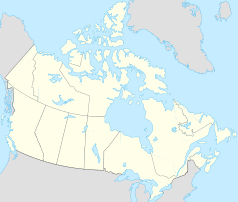
| Location in Yukon | ||
|
|
||
| State : |
|
|
| Territory : | Yukon | |
| Coordinates : | 60 ° 4 ′ N , 128 ° 43 ′ W | |
| Area : | 6.11 km² | |
| Residents : | 790 (as of 2016) | |
| Population density : | 129.3 inhabitants / km² | |
| Time zone : | Pacific Time ( UTC − 8 ) | |
| Postal code : | Y0A 1C0 | |
| Area code : | +1 867 | |
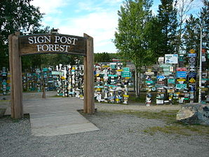
 Watson Lake - Sign Post Forest |
||
Watson Lake is a community in the southeast of the Canadian Yukon Territory on the Alaska Highway (also Yukon Highway 1) and the "gateway to the Yukon River ". It is one of only eight official municipalities in the territory and has the legal status of a small town ( English Town ). The Liard River flows south of the parish .
The place is best known for the Sign Post Forest , which was started in 1942 by a homesick soldier. Today it includes around 80,000 street, town and other signs from tourists from all over the world.
Demographics
The last official census , the 2016 Census , showed a population of 790 inhabitants for the municipality, after the 2011 census still showed a population of 802 inhabitants for the municipality. The population decreased by 1.5% compared to the last census in 2011 and developed contrary to the average for the territory, there with a population increase of 5.8%. In the 2006 to 2011 census period, the number of inhabitants in the municipality had already decreased by 5.2%, while the average for the territory increased by 11.6%.
At the 2016 census, the average age of the residents was 41.4 years, above the territory's average of 39.1 years. The median age of the residents was determined to be 45.0 years. The median age of all residents of the territory was 39.5 years in 2016. For the 2011 census, a median age of 42.4 years was determined for the inhabitants of the municipality, and 39.1 years for the inhabitants of the territory.
climate
The climate in Watson Lake is cold- temperate ( Dfc according to the Köppen and Geiger climate classification ). The average temperature in July is 15.3 ° C and in January −22.5 ° C and the annual average is −2.4 ° C.
The lowest temperature ever recorded was on January 31, 1947 at −58.9 ° C.
traffic
Watson Lake is at the junction of the Alaska Highway and the Robert Campbell Highway (also Yukon Highway 4). The city can also be reached via Watson Lake Airport . The local airport ( IATA airport code : YQH, ICAO code : CYQH, Transport Canada Identifier: -) is located approximately 10 kilometers northwest of the community. Officially, the airfield only has a runway of 1,677 meters in length.
Web links
Remarks
- ^ A b Watson Lake Community Profile. Census 2016. In: Statistics Canada . August 9, 2019, accessed on September 21, 2019 .
- ^ Sign Post Forest Homepage. In: signpostforest.com. Gary Lindley, accessed September 21, 2019 .
- ^ Watson Lake Community Profile. Census 2011. In: Statistics Canada . May 31, 2016, accessed on September 21, 2019 .
- ↑ 1981 to 2010 Canadian Climate Normals station data. Environment and Climate Change Canada , June 11, 2019, accessed September 21, 2019 .
- ^ Richard Cannings, Sydney Cannings: The New BC Roadside Naturalist. A Guide to Nature along BC Highways , Greystone Books, Vancouver 2002, 2013, p. 270.
- ↑ Canadian Airports Charts. (PDF; 76.9 MB) NAV CANADA , accessed on September 21, 2019 (English).
