Cobblestone Path
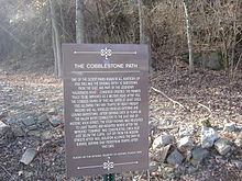
The Cobblestone Path is a historic trail in Bardstown , Kentucky that runs along the eastern side of the Bardstown Historic District . Originally longer than it is today, due to various later construction works, its existence is now limited to the section between Flaget Avenue and Broadway of the city and is directly opposite the Civil War Museum . Because the trail has always been part of the city's road system, it still belongs to the City of Bardstown today. It is only used by pedestrians.
The Cobblestone Path was built in 1785. All non-worshiping men from Bardstown between the ages of 16 and 50 were required to participate in the construction of this or other streets in the city, or pay $ 1.25 clearance for each day that they did not do the assigned work. From 1785 to 1825, the trail served as the main gateway to Bardstown and the Wilderness Road . Because of this importance, Kentucky and the United States Congress funded the pre-1800 improvements. For a short time the trail was part of the Louisville and Nashville Turnpike . When the highways to Bloomfield and Springfield were built, traffic on the Cobblestone Path was reduced to pedestrians and riders.
The Cobblestone Path is on a steep slope formed by the canyon of Stewart's Creek Towne Branch - on the other bank is My Old Kentucky Home State Park . Today, the trail is 350 feet (around 107 meters) long and varies between four and five feet in width. The dolomite - limestone blocks that were used to pave the way, are not formed uniformly; their thickness ranges from 15 to 25 cm. Natural rock fall and even a limestone boulder lie next to the path. The upper section was a popular picnic spot between the 1870s and 1900 and was named Lovers Leap over time . About ten meters below this point there is a dry cave that is hardly accessible.
Soil erosion has been a threat to the existence of the path since it was first founded, in the lower area only a few of the stones are preserved in their place. During the 1920s and 1930s, local Mrs. Ernest Fulton planted many plants along the path to help counteract erosion. With the honeysuckle , evergreen plants , narcissus and the natural thicket, climbing plants and local hardwoods that she has planted , the path practically represents a kind of walk through the undergrowth .

On November 16, 1989, the Cobblestone Path was added to the National Register of Historic Places as a structure because of its importance to the history of transportation in Kentucky .
swell
- David H. Hall: Cobblestone Path NRHP Nomination Form . CLG / Preservation Program, Bardstown, August 1989.
- Dixie Hibbs: Bardstown: Hospitality, History and Bourbon . Arcadia Publishing, 2002, ISBN 0738523917 .
Individual evidence
- ↑ a b c Cobblestone Path ( English ) Our Historic Places. Archived from the original on January 7, 2009. Info: The archive link was automatically inserted and not yet checked. Please check the original and archive link according to the instructions and then remove this notice. Retrieved February 6, 2009.
- ^ Hall, pp. 7–1.
- ^ Hibbs, 11
- ^ Hall, pages 8–1.
- ^ Hall, pp. 8–4.
- ^ Hall, pp. 7–2.
- ^ Hall, pp. 7–4.
- ^ Hall, pp. 8-1
- ↑ Entry in the National Register Information System . National Park Service , accessed June 12, 2016
Coordinates: 37 ° 48 '36 " N , 85 ° 27' 46" W.

