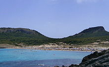
Coll de Marina
| Coll de Marina | |||
|---|---|---|---|
|
Coll de Marina, view from the northwest from Cala Mesquida, in the foreground the beach of Cala Mesquida |
|||
| Pass height | 84 m | ||
| region | Balearic Islands , Spain | ||
| Map (Balearic Islands) | |||
|
|
|||
| Coordinates | 39 ° 44 '0 " N , 3 ° 26' 30" E | ||
Coll de Marina is a mountain saddle in the northeast of the Spanish Mediterranean island of Mallorca .
It is located in the municipality of Capdepera between the 271 meter high Es Telégraf to the northeast and the 234 meter high Puig de s'Àguila to the southwest . The lowest point of the saddle is 84 meters high. A hiking trail leads across the saddle from Cala Mesquida in the northwest to Cala Agulla in the southeast . There are several ruinous remains of historical buildings along the way. In addition, a narrow mountain path leading to the summit of Es Telégraf begins near the Coll de Marina.


