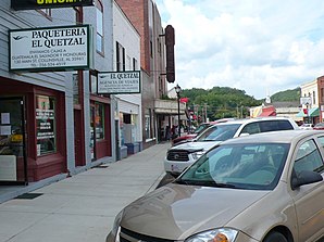
Collinsville, Alabama
| Collinsville | |
|---|---|
 In the town center (2009) |
|
| Location in County and Alabama | |
| Basic data | |
| State : | United States |
| State : | Alabama |
| County : | DeKalb County |
| Coordinates : | 34 ° 16 ′ N , 85 ° 52 ′ W |
| Time zone : | Central ( UTC − 6 / −5 ) |
| Residents : | 1,667 (as of 2005) |
| Population density : | 183.2 inhabitants per km 2 |
| Area : | 9.1 km 2 (approx. 4 mi 2 ) of which 9.1 km 2 (approx. 4 mi 2 ) is land |
| Height : | 214 m |
| Postal code : | 35961 |
| Area code : | +1 256 |
| FIPS : | 01-16600 |
| GNIS ID : | 0150164 |
| Website : | www.collinsvillealabama.net |
Collinsville is a location in DeKalb County , Alabama . The total area of the place is 9.1 km². In a 2005 estimate, Collinsville had 1,667 residents.
Demographics
According to the 2000 census, Collinsville had 1,644 residents, spread across 565 households and 367 families. The population density was 179.8 inhabitants / km². 63.32% of the population were white and 16.18% were African American. Children under the age of 18 lived in 29.9% of households. The median income per household was $ 21,964, with 25.7% of the population living below the poverty line .
history
One site in Collinsville is listed on the National Register of Historic Places (as of November 13, 2019), the Collinsville Historic District .
source
Individual evidence
-
↑ Search mask database in the National Register Information System. National Park Service , accessed November 13, 2019.
Weekly List on the National Register Information System. National Park Service , accessed November 13, 2019.
Collinsville Historic District on the National Register Information System. National Park Service , accessed November 13, 2019.
