Conn-Bächli
| Conn-Bächli | ||
|
Just before the cable car to Lake Cauma |
||
| Data | ||
| location | Flims municipality , Imboden district , Graubünden , Switzerland | |
| River system | Rhine | |
| origin | Dissipation from Flem at Runca 46 ° 50 '4 " N , 9 ° 16' 16" O |
|
| The End | at Conn coordinates: 46 ° 49 '0 " N , 9 ° 18' 59" E ; CH1903: 743.29 thousand / 186 784 46 ° 49 '0 " N , 9 ° 18' 59" O
|
|
| length | 6 km | |
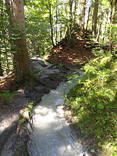
The Conn-Bächli is the most famous irrigation canal in the Flims rockslide area .
Fed by a derivation from the Flem below Runca, it reaches the meadow of Conn directly at the edge of the Rhine gorge Ruinaulta after about six kilometers of running . The most famous part is the passage on the slope to Lake Cauma , where the canal follows the path to Lake Cauma and passes under the station of the Caumasee lift .
Because no surface water flows in the entire area of the rubble of the Flims landslide, irrigation canals were built. Traces of these canals can be found both near Sagogn in the Bregl area and in Trin on Pintrun. In the area of the municipality of Flims, the Conn-Bächli and two other Bächli on Runca and Foppa have permanent water. Another channel can be followed in the Runca Sut / Staderas area. A branch to Lake Prau-Pulté was created from this canal , which should be used to indirectly raise the level of Lake Cauma in times of low water.
The difficulties that arose with the canals became apparent when a further historical canal was rebuilt from the Turnigla through the Belmont area to Fidaz : The canal, which was built by the civil defense in the 1980s, was unusable after a few years due to problems with the water intake and insufficient maintenance become.
In the past fifty years, the Conn-Bächli has also seen carelessness again and again: When a new forest road was built in the Uaul da Teua area in the 1970s, no pipes were laid for the canal and in the area below Runca the canal was replaced by a new one Adjusted the downhill route. After hunters had discovered that there was a lack of water and therefore a lack of game in the area, the canal was maintained again on their initiative and the missing underpass was built. This way, the water reaches the meadow near Conn, and farmers use it again for irrigation.

