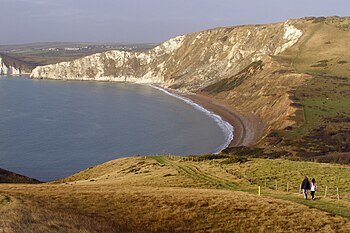
Cow Corner
Coordinates: 50 ° 37 '23 " N , 2 ° 11' 57" W.
Cow Corner is the northwestern landward end of Worbarrow Bay . Worbarrow Bay is located in the southwest of the Isle of Purbeck peninsula about 6 km south of Wareham and about 10 km east of Swanage in the county of Dorset on the south coast of England . Together with Mupe Bay to the west, it forms a kind of double bay, which is separated into an eastern (Worbarrow Bay) and a western (Mupe Bay) part by the small Bay of Arish Mell .
geology

Cow Corner is part of the Jurassic Coast , which since 2001 the part of World Heritage of UNESCO is. The geology of the Isle of Purbeck is very complex and this is very evident on this stretch of coast.
The sequences of the rocks of Worbarrow Bay and Mupe Bay are very similar and in fact mirrored. The cliffs in the south, at the back of the double bay, and thus also those of Cow Corner, consist of limestones from the Upper Cretaceous (commonly known as "chalk cliffs"). Towards the front of the double bay, in the direction of the open sea, there are increasingly older rocks. The Upper Cretaceous is followed by the Upper Green Sands , including the Gault Clay , and the sandstone-dominated Wealden layers of the Lower Cretaceous . The subsequent Purbeck layers, which are lithologically very varied, are in their deeper part of Upper Jurassic age. At the front of the double bay, in the area of the small Cape Worbarrow Tout and the Mupe Rocks , limestones of the Upper Jurassic Portland Stone Formation complete the sequence. All layers have been straightened up tectonically and dip at about 45 to 60 degrees.
- See also geology of the Isle of Purbeck
