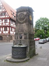
Dürer-Pirckheimer fountain
The Dürer-Pirckheimer-Brunnen (sometimes incorrectly referred to as the Albrecht-Dürer-Brunnen ) is a classicist architectural fountain in Nuremberg . The work, created in 1821 based on a design by Carl Alexander von Heideloff , is dedicated to two important intellectuals of the old imperial city of Nuremberg , the painter and polymath Albrecht Dürer and the humanist Willibald Pirckheimer .
history
A good ten years after the romantic-classical transformation of the baroque Maxplatzes (formerly "Neuerbaw" New Construction) - the elongated road space was planted with two rows of trees - was in 1821 the well of the master stonemason George Cappeller according to plans by Carl Alexander von Heideloff in strictly classical forms. The fountain is one of the few known classicist works by Heideloff, who was otherwise caught up in the romanticizing neo-Gothic style.
He was instead one of the missing side of the fountain Triton fountain to as an accent on the eastern end of the square and as visible brand Maxbruecke set. The center of the square has been dominated by the baroque Triton Fountain since 1687. A counterpart to the Dürer-Pirckheimer fountain, originally intended at the west end of the square in terms of longitudinal symmetry, was no longer erected.
Political and historical background
The fact that both of the honored persons were close to Protestantism and were humanistically shaped free thinkers and that the formal language of the monument is very much based on the Prussian state architecture Schinkel can be assessed as symbolic of the inner distance to the Catholic Kingdom of Bavaria. At the time of installation, Nuremberg, the majority of whose citizens felt foreign to post-Napoleonic Bavaria, had only lost its imperial immediacy and sovereignty in the past fifteen years and had become a simple provincial town. The fountain was intended to be a conscious reminder of the former importance of the former Free Imperial City as a European center of humanism and, against this background, must be understood as an expression of the self-confidence of the enlightened citizens.
description
Fountain architecture and medallions
The fountain is made of sandstone and has the basic shape of a squat obelisk . To the side - south and east - are two semicircular metal basins on a stepped plinth made of sandstone. Two metal lion masks as gargoyles are attached to the obelisk above the basin. The obelisk has two gold-plated medallions adorned with garlands . The western medallion facing the inside of the square shows the portrait of the humanist Willibald Pirckheimer; the eastern medallion facing Karlstrasse shows Albrecht Dürer. The north and south sides of the obelisk show the great Nuremberg coat of arms with the virgin eagle carved in sandstone at the level of the medallions .
Current condition
The fountain has largely been preserved in its original state and with the natural patina of the sandstone areas in good condition. The medallions were newly gilded.
See also
literature
- Günther P. Fehring, Anton Ress: The city of Nuremberg. Brief inventory. Deutscher Kunstverlag, Munich / Nuremberg 1977, ISBN 3-422-00550-1 .
- Elke Masa: Free sculptures in Nuremberg - sculptures, monuments and fountains in the public space of the city. Schmidt, Neustadt / Aisch 1994, ISBN 3-87707-479-0 .
Web links
Individual evidence
- ↑ The renaming of the square in Maximilianplatz (later and still Maxplatz ) happened after the successful incorporation of Nuremberg in 1806 in the Kingdom of Bavaria in honor of the then reigning king Maximilian I. .
- ↑ Originally the Triton Fountain had two smaller side fountains, which were set up at the western and eastern ends of the square, as far as recognizable on a steel engraving by Delsenbach, dated 1720. The whereabouts of these side wells is unclear.
Coordinates: 49 ° 27 ′ 14.9 " N , 11 ° 4 ′ 23.5" E


