Dahme flood canal
The Dahme-Umflutkanal is a canal that connects the Spree from Leibsch over the Köthener See to Märkisch Buchholz with the Dahme .
Origin and function
The construction of the Dahme Umflut Canal goes back to a resolution of the Prussian Ministry of Public Works in 1904. The basis was the law for the prevention of floods of August 4, 1904, which was enacted because major damage had been caused by numerous floods in the Spree in previous years. The construction of the Dahme flood canal including the canal bridge and the weir systems with needle and panel weirs took place between 1907 and 1911.
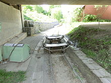
The Dahme Flood Relief Canal has the function, Spreewald to protect against flooding and navigability to allow the Dahme. The Dahme-Umflutkanal is state waterway of class C. Because of the two barrages with weir in Märkisch-Buchholz, the canal is not navigable continuously. The boat tows can be used with small boats up to 350 kg. The lowest bridge clearance height is 2 m.
The Dahme flood canal is part of the main water hiking route 2 in the state of Brandenburg.
course
- 009.5 km - Start of the canal at Leibsch (Spree) at the double lock
- 006.4 km - confluence with the Koethener See
- 005.0 km - outflow from Lake Koethen
- 001.0 km - weir with manually operated boat tow in front of Buchholz
- 000.2 km - weir with electrically operated boat tow for boats up to 350 kg
- 000.0 km - confluence with the Dahme in Märkisch-Buchholz at 40.8 km
Web links
swell
- ↑ Document construction of the flood canal
- ↑ Receipt and map of the main water hiking route 2 ( memento of the original from February 11, 2014 in the Internet Archive ) Info: The archive link was automatically inserted and not yet checked. Please check the original and archive link according to the instructions and then remove this notice. (PDF; 5.7 MB)
literature
- Lake areas between Berlin and the Spreewald (Upper Spree waterway with Schwielochsee, Dahme-Umflutkanal), DSV-Verlag, 1995
Coordinates: 52 ° 4 '58.8 " N , 13 ° 49' 5.1" E

