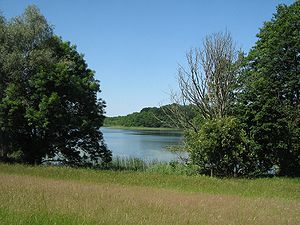
Dambecker See (Kratzeburg)
| Dambeck lake | ||
|---|---|---|

|
||
| Geographical location | District of Mecklenburg Lake District | |
| Tributaries | in the north of Pieverstorfer See | |
| Drain | to Röthsee | |
| Places on the shore | Dambeck , Pieverstorf | |
| Data | ||
| Coordinates | 53 ° 26 '53 " N , 12 ° 56' 48" E | |
|
|
||
| Altitude above sea level | 63.5 m above sea level NHN | |
| surface | 39.3 ha | |
|
particularities |
Castle ramparts on the bank |
|
The Dambecker See is a lake in the municipality of Kratzeburg in the Mecklenburg Lake District in Mecklenburg-Western Pomerania . The lake has a strongly structured shape with several distinctive bays. It is 1100 meters long and up to 600 meters wide. Larger parts of the shore are forested. At the southwest end is the eponymous place Dambeck and in the northeast is Pieverstorf on the shore. South of Pieverstorf there is a Bronze Age castle wall on the bank. It is one of the largest of its kind in northern Germany. The heights around the lake reach up to 96 m above sea level in the south . NHN .
On the north side of the Dambeck lake, the young Havel flows from the Pieverstorfer Kunke (Pieverstorfer Kuncke, also partly called Pieverstorfer See) into the lake. The Pieverstorfer Kunke is separated from the Dambeck lake by an approx. 120 meter wide silting zone and has a surface connection to the new symbolic source of the Havel via the "Großer Dieckensee" (large Diecksee) and the "Kleiner Dieckensee" (small Diecksee) .
The name of the water is derived from Dambeck. This place name probably comes from the Slavic word "Dab or Dabele" for "oak" and "Bek" for "Bach", ie "Eichenbach".
The lake is located in the Müritz National Park .
