Darrell's Island
| Darell's Island | ||
|---|---|---|
|
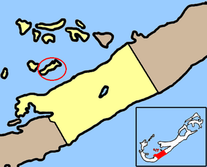
Warwick Parish map (Darell's Island is circled) |
||
| Waters | Atlantic Ocean | |
| Archipelago | Bermuda | |
| Geographical location | 32 ° 16 ′ 30 ″ N , 64 ° 49 ′ 16 ″ W | |
|
|
||
| length | 750 m | |
| width | 120 m | |
| surface | 9 ha | |
| Highest elevation | 6 m | |
Darell's Iceland sporadically, even Darell Iceland called, is a island of Bermuda , located in the southeast of the Great Sound ( Great Sound ), about 600 meters north before Grand Bermuda . The island is part of the Warwick Parish administrative area .
Darell's Island is flat and narrow, about 750 meters long and on average only 120 meters wide. It forms the largest and most easterly link in a small chain of islands , to which (from west to east) Grace Island , Rickett's Island and Burt's Island belong. The latter is barely 100 meters west of Darell's Island.
From 1930 to 1948 there was a flying boat station built by the former British airline Imperial Airways on the island, which is now sparsely developed . This served initially as a civil airport , later as a military base for the Royal Air Force .
Since the air base on Darell's Island was closed in 1948, the only Bermudian airport has been on the island of Saint David’s located 15 kilometers to the northeast .
See also
- List of the islands of Bermuda
- LF Wade International Airport (Bermuda Airport)

