
Daschower See
| Daschower See | ||
|---|---|---|

|
||
| Geographical location | Ludwigslust-Parchim district | |
| Tributaries | from Neuhöfer See | |
| Drain | partly underground to the Elde | |
| Places on the shore | Daschow | |
| Location close to the shore | Plau am See | |
| Data | ||
| Coordinates | 53 ° 30 '19 " N , 12 ° 10' 2" E | |
|
||
| Altitude above sea level | 56.3 m above sea level NHN | |
| surface | 14.6 ha | |
| Maximum depth | 11.09 m | |
| Middle deep | 5.5 m | |

The Daschower Lake is located north of Lübz in the municipality Gallin-Kuppentin in the district Ludwigslust-Parchim in Mecklenburg-Vorpommern . The eponymous place Daschow is located on the south bank of the lake. There is a bathing area here and Daschow Castle in the far south . The lake is about 11 m deep, 400 m wide and over 500 m long. The tributary lies in the north and forms the connection to Lake Neuhöfer . Not far from the west bank is the Daschower Moor nature reserve .
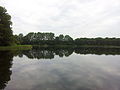
View from the bathing area to the west

View from the bathing area to the north

