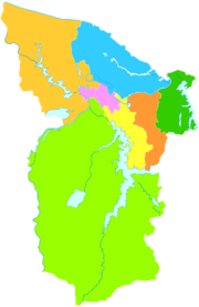
Datong (Huainan)
The Datong District ( Chinese 大通 区 , Pinyin Dàtōng qū ) is a district of the prefecture -level city of Huainan in the Chinese province of Anhui . The administrative area of the city district has an area of 306 km² and has approx. 186,000 inhabitants (2018).
geography
The municipality lies in the alluvial plain of the Huai He , which borders it in the northwest. The Huai He is 65 to 115 meters wide and 2.5 to 9.5 meters deep in the area of the municipality. On the eastern border is the Gaotang Lake (高 塘 湖) with a water surface of about 25 km². In the northeast of the city district lies the Shangyao Shan (上 窑 山) with five mountain ranges and two reservoirs: the Quanyuan Reservoir (泉源 水库) with a capacity of 600,000 cubic meters and the Huaguoshan Reservoir (花果山 水库), which consists of two reservoirs with a total of 140,000 cubic meters of water. The highest mountain of the Shangyao Shan is the Zhujia Shan (家 大 山) at 212 meters; nine other mountains of the Shangyao Shan are over 200 meters high. There are many springs in the Shangyao Shan whose water is used to supply Huainan with drinking water. In the west of the city district is the Shungeng Shan mountain range .
economy
The municipality has 44 km² of agricultural area. The Gaotang Lake is used for aquaculture.
history
Today's large communities Shangyao (上 窑 镇) and Luohe (洛河 镇) have a history of more than 1400 years. Shangyao was one of seven centers of porcelain manufacturing during the Tang Dynasty , Luohe was once an important trading port on Huai He. In Datong (大通街道) and Jiulonggang (九龙岗镇) the birth places are of coal mining in Huainan Basin. The dismantling began in the Ming and Qing dynasties and was also used for porcelain production. Industrial coal mining began in 1910 in Jiulonggang on the south side of Shungeng Shan in Jiulonggang. A total of 32 million tons were mined; mining was stopped in 1982.
Administrative structure
At the community level, the city district is made up of a street district, three large municipalities and one municipality. These are:
- Road quarter Datong (大通街道)
- Greater community Shangyao (上窑镇)
- Luohe municipality (洛河 镇)
- Greater community Jiulonggang (九龙岗镇)
- Community Kongdian (孔店乡)
In 2004, the community was Kongdian from the circle Changfeng of the prefecture-level city Hefei separated and affiliated to Datong.
Web links
- Official Website (Chinese)
- Info page
Individual evidence
- ↑ Datong Official Website: Overview . Retrieved October 10, 2019.
- ↑ Datong Official Website: Geographical Overview . Retrieved October 11, 2019.
- ↑ Datong Official Website: Raw Materials . Retrieved October 10, 2019.
- ↑ Datong Official Website: History . Retrieved October 11, 2019.
- ↑ Datong Official Website: History . Retrieved October 11, 2019.
Coordinates: 32 ° 37 ' N , 117 ° 4' E
