Huainan
| Huainan | ||
|---|---|---|
|
|
||
| Coordinates | 32 ° 29 ′ N , 117 ° 1 ′ E | |
| Basic data | ||
| Country | People's Republic of China | |
| Anhui | ||
| ISO 3166-2 | CN-AH | |
| surface | 2526 km² | |
| Residents | 3,456,000 (2016) | |
| density | 1,368.2 Ew. / km² | |
| founding | 283 BC Chr. | |
|
Huainan
|
||
Huainan ( Chinese 淮南 市 , Pinyin Huáinán Shì ) is a district-free city in the Chinese province of Anhui . The administrative area of the city has an area of 5,533 km² and around 3.46 million inhabitants (end of 2016). In the actual urban settlement area of Huainan 1,238,488 people live (2010 census).
The site of the Shouzhou kiln (寿州 窑 遗址, Shòuzhōu yáo yízhǐ) located on their territory is on the list of monuments of the People's Republic of China .
geography
The city lies in the alluvial plain of the Huai He . On the south bank of the Huai He stretches from east to west an interrupted chain of hills with the mountains Bagong Shan (八 公 山) and Shungeng Shan (舜耕 山); the chain is part of the Jianghuai plain . It is 500 to 1500 meters wide and 40 to 75 meters high. Below the hill is the second terrace of the alluvial plain, with a height of 30 to 40 meters and a width of 500 to 2500 meters. The first terrace is 2500 to 3000 meters wide and about 25 meters high. The flooding level of the Huai He, below the first terrace, is 17 to 20 meters above sea level.
Administrative structure
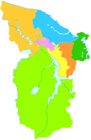
At the county level, Huainan is made up of five municipalities and two counties:
| map | ||||||
|---|---|---|---|---|---|---|
| Surname | chin. | Pinyin | Residents
(2003) |
surface
(km²) |
Population
density (/ km²) |
|
| Townships | ||||||
| Tianjia'an | 田家庵 区 | Tiánjiā'ān Qū | 500,000 | 239 | 2 092 | Seat of the city government |
| Datong | 大通 区 | Dàtōng Qū | 180,000 | 314 | 573 | |
| Xiejiaji | 谢 家 集 区 | Xièjiājí Qū | 330,000 | 273 | 1 209 | |
| Bagongshan | 八 公 山区 | Bāgōngshān Qū | 170,000 | 93 | 1 828 | |
| Panji | 潘集 区 | Pānjí Qū | 430,000 | 607 | 708 | |
| Circles | ||||||
| Fengtai | 凤台 县 | Fèngtái Xiàn | 700,000 | 1,000 | 700 | Main town: Chengguan (城关 镇) |
| Shou | 寿县 | Shòu Xiàn | 232,000 | 2,984 | 77 | Main town: Shouchun (寿春 镇) |
Shou County has been part of Huainan since 2015, until then it was under the administration of Lu'an Prefecture .
history
The city of Huainan was founded in 283 BC. Chr. Founded by farmers. Due to the large agricultural areas, the city quickly became the "breadbasket" of Anhui Prefecture.
In 1112 , Mayor Gohku Wong ordered a census that showed a population of 15,923.
After decades of growth and development, the so-called "black 50 years" began. From 1580 to 1630 there were no harvests on the fertile land around the city. There was a severe famine, the number of unemployed increased dramatically and a large emigration from the city began.
In 1630 there was a storm that lasted more than a week, which almost completely destroyed the city. After the storm had withdrawn, however, the fields were surprisingly fertile again, and the city began to be rebuilt, which was quickly followed by a renewed economic upswing.
The city became a cultural and religious center. In addition, the emperors built several residences and palaces in the district of the city.
Urban development
In 2008 , the 190 million RMB Dongshan Tunnel was opened. It opens up the southern urban area beyond the Dongshan range of hills that previously limited Huainan in the south. A large new urban district is being created on the formerly agricultural land. A rectangular road network has already been completed. Numerous housing estates are under construction; some were completed in early 2012. A concert hall in the form of a piano and a violin has already been built, and a theater is under construction. There are plans for an amusement park.
Web links
- Official Website (Chinese)
Individual evidence
- ↑ Huainan's official website: Geography . Retrieved October 1, 2019.


