
Davidstrasse (Hamburg)

The David Street in the district of Hamburg-St. Pauli belongs to a group of streets between the Reeperbahn and St. Pauli Hafenstraße , which were named with male first names in alphabetical order from A (like Antonistraße) to H (like Heinrichstraße or later Herbertstraße) after an official resolution of 1790. For the year 1832, Davidstrasse is described as a "sparse and so far only built-up alley" and a "poor district".
Branching off from the Reeperbahn, Davidstraße begins at the western end of Spielbudenplatz and opposite the junction with Hein-Hoyer-Straße ; the Davidwache police station is also located there . From there, the road runs almost 300 meters in the direction of the Elbe to Bernhard-Nocht-Straße . The Sankt-Pauli-Museum is located along this section, the famous brothel street Herbertstraße branches off to the west as well as various restaurants , snack bars and souvenir shops . At number 11 is the Cuneo , the first eatery in Hamburg with Italian cuisine ; among other things, guest workers who were involved in the construction of the old Elbe tunnel were fed here .
At the intersection with Bernhard-Nocht-Straße, the "Davidstreppe" leads down to the Elbe, almost in the alignment of the previous street, Davidstraße itself bends towards Landungsbrücken and flows about 200 meters further into the lower St. Pauli Hafenstraße . On this last section there is a continuous retaining wall on the north side , opposite an undeveloped slope .

Davidstrasse 1, corner of Bernhard-Nocht-Strasse
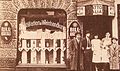
Davidstrasse 11: Restaurant Cuneo 1905

Davidstraße corner Friedrichstraße with St. Pauli Museum

David stairs on St. Pauli Hafenstrasse

Retaining wall on the slope facing Hafenstrasse


House numbers on Davidstrasse
Contrary to the officially established numbering of houses on one side of the street with even numbers and on the other with odd numbers, which is widespread in Hamburg, the numbering on Davidstraße begins at the intersection with Bernhard-Nocht-Straße on the west side with 1, continuously up to 26 at Spielbudenplatz, there changes to the eastern side of the street and has the continuous numbering from 27 to 37 again on Bernhard-Nocht-Straße.
Individual evidence
- ↑ NEDDERMEYER: "Topography of the Free and Hanseatic City of Hamburg" section "The streets of the suburb Hamburgerberg" Verlag Hoffmann & Campe, Hamburg 1832
- ^ Hanseatic City of Hamburg, Office for Building Regulations and Building Construction
Web links
Coordinates: 53 ° 32 ′ 52 " N , 9 ° 57 ′ 46" E