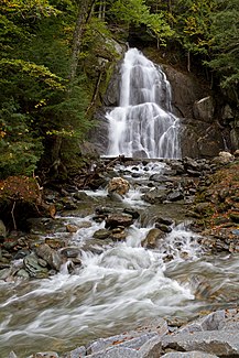
Deer Hollow Brook
| Deer Hollow Brook | ||
|
The Moss Glen Falls |
||
| Data | ||
| Water code | US : 1460783 | |
| location | Vermont , USA | |
| River system | Connecticut River | |
| Drain over | White River → Connecticut River → Atlantic Ocean | |
| source | Mountainside over the Moss Glen Falls 44 ° 2 ′ 3 ″ N , 72 ° 52 ′ 41 ″ W |
|
| muzzle | White River Coordinates: 44 ° 1 '3 " N , 72 ° 51' 0" W, 44 ° 1 '3 " N , 72 ° 51' 0" W. |
|
| Mouth height |
354 m
|
|
| Communities | Granville | |
The Deer Hollow Brook is a river in the Granville parish east of the main Green Mountains range in Vermont . It is a left tributary of the White River .
history
The particularly heavy rainfall in the region repeatedly causes flooding and tidal waves from Deer Hollow Brook. The strongest recorded flood occurred on July 26, 1830. At that time, after several days of heavy rainfall, a landslide blocked the gorge near Moss Glen Falls and dammed the river by about 25 meters (75 feet). When the dam gave way after three days, the resulting tidal wave reached a height of around 20 meters. The tidal wave did not claim any human life because there was enough time to get to safety. The property damage - especially destroyed houses and washed away bridges - was considerable.
Sights and buildings
A few meters before crossing under Vermont Route 100 , the water plunges over several cascades around 22 meters into the depth, forming the Moss Glen Falls .
Web links
- http://us.geoview.info/deer_hollow_brook,5235408
- http://www.hookandbullet.com/fishing-deer-hollow-brook-randolph-vt/
Individual evidence
- ↑ Copy of the book by HP Smith, History of Addison County, Vermont , Syracuse, NY, 1886, Chapter 22, Page 462 f (English) ( Memento of the original from August 16, 2014 in the Internet Archive ) Info: The archive link was inserted automatically and not yet checked. Please check the original and archive link according to the instructions and then remove this notice.
