Dellplatz
| Dellplatz | |
|---|---|
| Place in Duisburg | |
 Dellplatz with the parish church of St. Joseph |
|
| Basic data | |
| place | Duisburg |
| District | Dellviertel |
| Hist. Names | Papendelle |
| Confluent streets | Dellstrasse, Neue Marktstrasse, Wallstrasse, Grünstrasse, Papendelle |
| use | |
| User groups | Pedestrian traffic , motor vehicles , parking lots |
| Technical specifications | |
| Square area | approx. 9300 m² |
Dellplatz is a Duisburger Platz in the center of the so-called Dellviertel south of Friedrich-Wilhelm-Straße and west of Düsseldorfer-Straße, which leads past Kantpark .
The square was called Papendelle in the 19th century. The name Neumarkt was provided for in the city's building plan drawn up in 1850. Since 1890 the address books show the place as Dellplatz.
Before the Second World War , the Dellviertel was called Papendell. The name comes from the Low German term for valley and refers to the valley of the Dickelsbach . The square covers the area of the Church of St. Joseph and the hexagonal square to the east.
Dellplatz is a cultural center in Duisburg. In addition to the cabaret theater “The Column” and the Grammatikoff cultural center, there is the Filmforum and the Webster brewery.
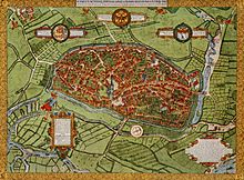
The Dellviertel was outside the former city walls. On the Corputius plan , the very detailed plan of Duisburg made by Johannes Corputius from a bird's eye view, the river basin of the Dickelsbach and the location of today's Dellplatz can be seen in the upper right part.
The road network in the Dellviertel was expanded by the end of the 19th century. The Papendell emerged from the expansion of a street intersection and became a central marketplace. Up until the 20th century, the district was home to various commercial operations such as textile spinning mills, sugar, soap and starch factories. Today there are residential buildings in these places.
Web links
- http://www.dellplatz.de/ What's going on at Dellplatz?
Individual evidence
- ↑ http://www.bz-duisburg.de/Du_strassen_plz/Du_Ortsteile_strassennamengeschichte/dellviertel_C_D.htm street name history.
- ↑ Archive link ( Memento of the original from March 4, 2016 in the Internet Archive ) Info: The archive link was inserted automatically and has not yet been checked. Please check the original and archive link according to the instructions and then remove this notice. City of Duisburg.
Coordinates: 51 ° 25 ′ 48 ″ N , 6 ° 45 ′ 42 ″ E
