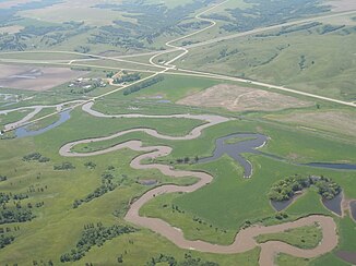
Des Lacs River
|
Des Lacs River Riviere des Lacs, Rivière des Lacs |
||
|
Des Lacs River 10 km above the estuary, in the background the US Highways 2 and 52 meet |
||
| Data | ||
| Water code | US : 1028667 | |
| location |
Saskatchewan ( Canada ), North Dakota (USA) |
|
| River system | Nelson River | |
| Drain over | Souris River → Assiniboine River → Red River of the North → Nelson River → Hudson Bay | |
| Headwaters | 4 km north of the US border 49 ° 2 ′ 14 " N , 102 ° 21 ′ 42" W |
|
| Source height | approx. 560 m | |
| muzzle |
Souris River Coordinates: 48 ° 16 ′ 48 " N , 101 ° 25 ′ 8" W 48 ° 16 ′ 48 " N , 101 ° 25 ′ 8" W |
|
| Mouth height | 475 m | |
| Height difference | approx. 85 m | |
| Bottom slope | approx. 0.5 ‰ | |
| length | approx. 170 km | |
| Catchment area | 2432 km² near Foxholm, 25 km above the mouth | |
| Discharge at Foxholm A Eo gauge : 1396 km². Location: 25 km above the mouth |
MQ 1946/2017 Mq 1946/2017 |
940 l / s 0.7 l / (s km²) |
| Reservoirs flowed through | Upper Des Lacs Lake, Middle Des Lacs Lake, Lower Des Lacs Lake |
|
| Small towns | Burlington , Donnybrook , Kenmare | |
| Communities | Carpio , Foxholm | |
The Des Lacs River (in Canada: Riviere des Lacs ) is a 170 km long right tributary of the Souris River in the Canadian province of Saskatchewan and in the US state of North Dakota .
River course
The river has its source in southeast Saskatchewan, 4 km north of the US border at an altitude of about 560 m . It initially flows 7 km in an easterly direction and flows into the upper end of the 47 km long Upper Des Lacs Lake , the upper 4.5 km of which are in Canada. The Des Lacs National Wildlife Refuge extends along the reservoir. Below Upper Des Lacs Lake , the Des Lacs River flows 2.6 km to the top of the 3.5 km long Middle Des Lacs Lake . The small town of Kenmare is located on the east bank . After another 3.4 km the river reaches the 4.5 km long Lower Des Lacs Lake . The Des Lacs River flows southeast for the lower 90 km. It shows a strongly meandering behavior with numerous river bends and oxbow lakes . It passes the towns of Donnybrook , Carpio and Foxholm , before flowing into the Souris River at Burlington , 10 km northwest of Minot . The US Highway 52 follows 20 kilometers south of the US border to the river to its mouth.
Hydrology
At the gauge at Foxholm, 25 km above the mouth, the catchment area covers 2432 km². The effective catchment area at this point is only 1396 km². The annual outflows fluctuate strongly. The mean discharge is 0.94 m³ / s.
Web links
- Riviere des Lacs at Natural Resources Canada
